What Nobody Tells You Before You Plan a Southwest Road Trip
Here's what the travel magazines conveniently omit about a Southwest road trip through Four Corners: most of the destinations that define the region sit at the end of unpaved roads that the rental SUV in the brochure photograph isn't contractually permitted to drive on, the distances between Utah's slickrock and Colorado's San Juan high country are longer and more remote than any single-day itinerary makes workable, and the gap between a paved-route windshield tour and the genuine backcountry experience that brings adventurers to this corner of the country is measured in vehicle capability and time, not enthusiasm.
A Southwest road trip isn't a checklist of national park visitor centers connected by interstate highway. It's a three-state circuit through some of the most varied terrain on the continent—sandstone canyons, alpine mining districts, ancient cultural sites, and high desert that holds its scale only when you're inside it. The Four Corners region produced more silver and gold than most countries during the 19th century, anchored civilizations that built sandstone cities a thousand years before European contact, and now contains more designated wilderness, BLM backcountry, and Forest Service public land per capita than anywhere else in the lower 48.
Hundreds of thousands of visitors attempt some version of a Southwest road trip each year. The ones who get the most out of it—and avoid the rental damage disputes, missed destinations, and "we just drove past it" regrets that scenic-route itineraries consistently produce—are the ones who arrive understanding that the best of this region isn't visible from pavement.
Southwest Road Trip at a Glance
The basics:
Total distance:
900–1,400 miles depending on chosen routes and side trips
States covered:
Utah, Colorado, Arizona, New Mexico—the only point in the United States where four states meet at a single corner
Anchor destinations:
Moab and Canyonlands (Utah), the San Juan Mountains (Colorado), Monument Valley (Utah/Arizona), Mesa Verde (Colorado), and the Four Corners Monument
Typical season:
April through October for the full circuit; high-elevation Colorado sections close November through April
Trip duration:
7–10 days for a representative circuit, 14+ days to do the region justice
Vehicle requirement:
High-clearance 4WD with low-range gearing for legitimate access to the destinations that justify the trip
What it covers:
A proper Southwest road trip combines the slickrock canyon country of southeast Utah, the alpine mining corridors of southwest Colorado, the cultural and geological landmarks of the Four Corners plateau, and the high desert transitions in between. The route can be driven in either direction, started from any of several anchor cities, and customized around personal interests in geology, archaeology, or backcountry technical driving. What it cannot be done justice on is a paved-only itinerary—too many of the region's defining destinations sit at the end of dirt roads that highway rentals prohibit and stock crossovers can't navigate confidently.
Designated status:
The Southwest road trip route passes through five national parks (Arches, Canyonlands, Mesa Verde, Black Canyon of the Gunnison, and depending on routing, the Grand Canyon's North Rim), three national monuments, multiple national forests, the Navajo Nation, and BLM-managed public land that contains some of the most significant backcountry recreation infrastructure in the country. Several segments of the trip overlap with formal Scenic Byway designations, including the San Juan Skyway and the Trail of the Ancients.
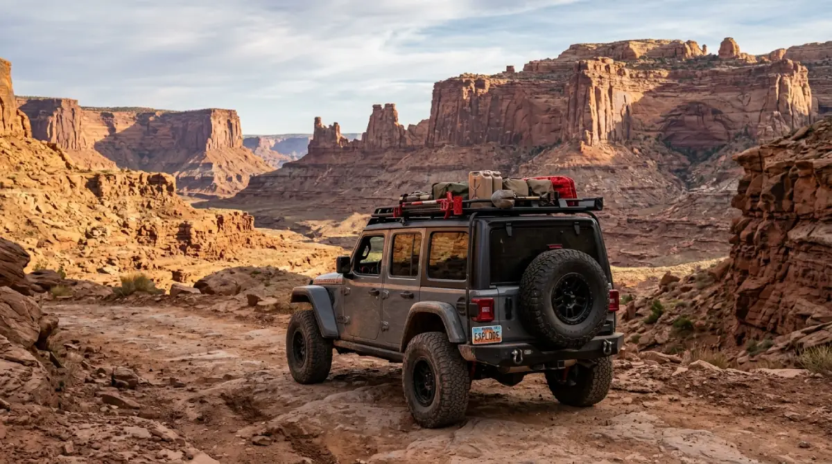
The Utah Leg: Moab and the Canyon Country
The Utah leg of a Southwest road trip is what brings most visitors to the region in the first place—the slickrock canyons, sandstone arches, and rock formations that have anchored Western photography since the 1920s. The leg centers on Moab, with Arches and Canyonlands national parks framing the town and the BLM backcountry surrounding both providing the technical and scenic depth that the parks themselves can't fully deliver.
What the parks deliver:
Arches National Park concentrates the region's most photographed sandstone formations—Delicate Arch, Landscape Arch, the Windows section—into a paved scenic loop accessible to any vehicle. Canyonlands' Island in the Sky district provides the panoramic overlooks that explain the scale of the canyon system. Both parks deliver in 1–2 days what casual visitors traveled the region for.
What the backcountry adds:
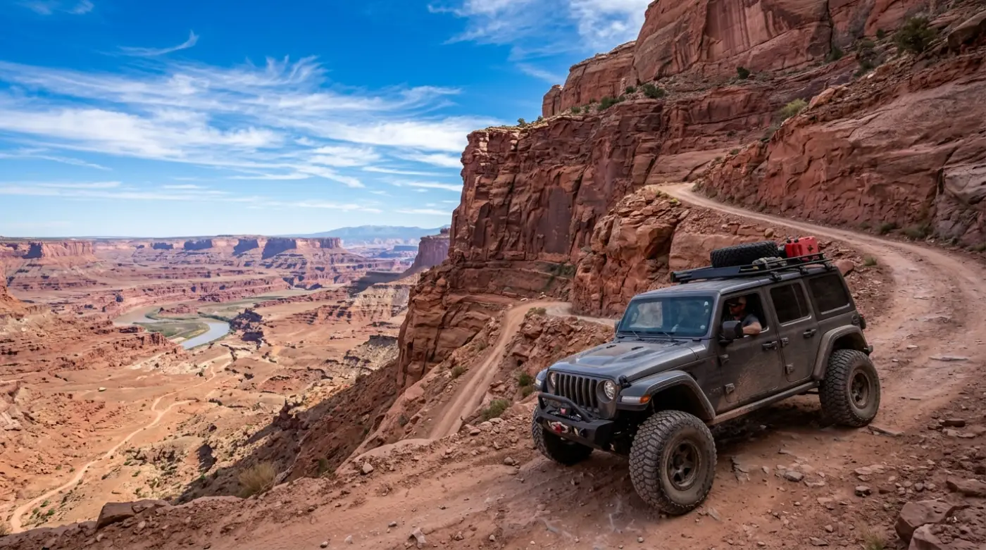
Moab's defining experiences sit outside the park boundaries. Hell's Revenge, Fins N Things, Top of the World, and the Shafer Trail descent into Canyonlands' lower districts require permits or capable vehicles or both. The White Rim Road's 100-mile circuit through Canyonlands needs 2–3 days minimum and capability beyond stock vehicles. Monument Valley's interior loop on the Arizona-Utah border similarly requires 4WD or guided access.
Technical specifics:
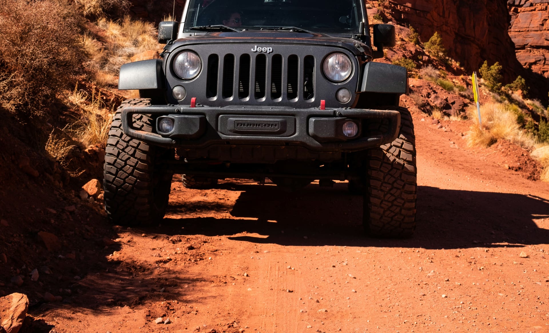
Moab-area named trails (Hell's Revenge, Poison Spider, Fins N Things, Top of the World) require modified 4WD with proper clearance and tire grip; stock rental Wranglers from major brands prohibit off-road use entirely
The Shafer Trail descent from Island in the Sky into Canyonlands' White Rim is high-clearance 4WD; mid-tier modified rentals handle it confidently
Monument Valley's interior 17-mile scenic loop is unpaved washboard and sand; high-clearance vehicles strongly recommended
Cell service is reliable in Moab itself but drops quickly on any backcountry trail; download offline maps before departure
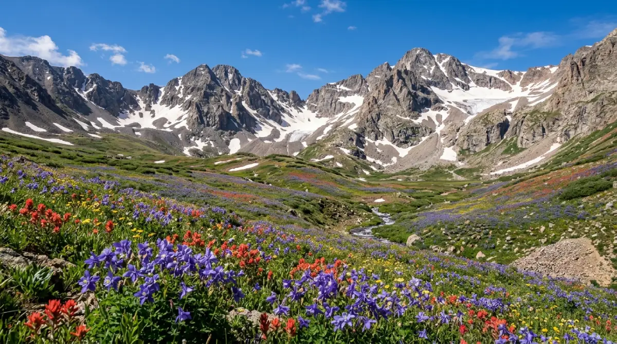
The Colorado Leg: San Juan Mountains
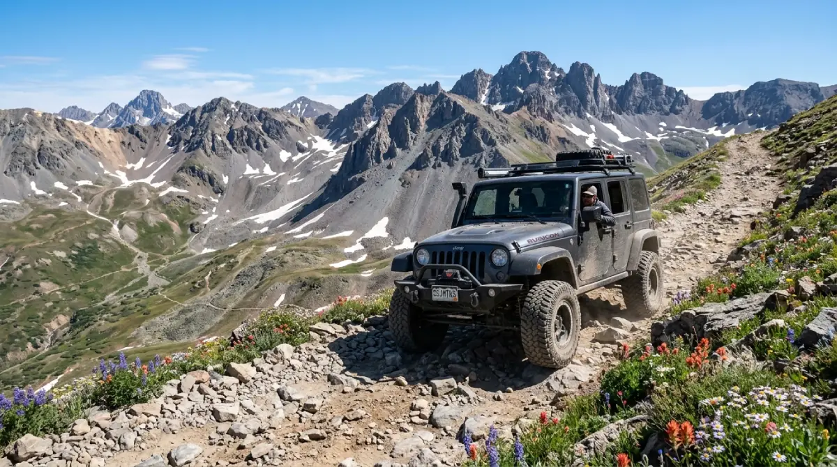
The Colorado leg shifts the road trip's character completely—from sandstone desert to alpine high country, from sea-level-equivalent breathing to 11,000-foot pass summits, from technical slickrock to technical scree. The San Juan Mountains contain Colorado's highest concentration of historic mining infrastructure, the most famous 4x4 backcountry byways in the state, and three of the most scenic mountain towns in the American West.
What the route delivers:
The San Juan Skyway loops 236 miles through Durango, Telluride, Ouray, and Silverton on paved highway—accessible to any vehicle and genuinely worth driving for visitors short on time. The legitimate San Juan experience sits off the skyway: the Alpine Loop's Engineer Pass and Cinnamon Pass connecting Lake City to Silverton, Imogene Pass connecting Telluride to Ouray, and Black Bear Pass for drivers with the experience and equipment to handle Colorado's most exposed driveable road.
The historical layer:
The mining infrastructure scattered through the San Juan high country dates to the 1870s and 1880s—boom-and-bust silver and gold operations that built towns at 11,000 feet, hauled ore on tramways across alpine valleys, and abandoned the entire enterprise when the silver crash of 1893 made the economics impossible. Animas Forks ghost town, Tomboy townsite above Telluride, and dozens of preserved mine ruins make the Colorado leg as much an industrial archaeology trip as a scenic one.
Technical specifics:
The named San Juan passes (Engineer, Cinnamon, Imogene, Black Bear) all require high-clearance 4WD with 4LO low-range capability; stock vehicles and AWD crossovers consistently get into trouble on the descents
Afternoon thunderstorms develop above 11,000 feet by 2 PM most summer days—plan to be off exposed sections before noon
Snow can fall any month of the year above 11,000 feet; the high passes typically open late June through September only
The high-altitude terrain causes 25%+ of unacclimatized visitors to develop mild altitude sickness symptoms; build acclimatization time into the itinerary
The Four Corners Cultural Heart: Mesa Verde and the Ancestral Sites
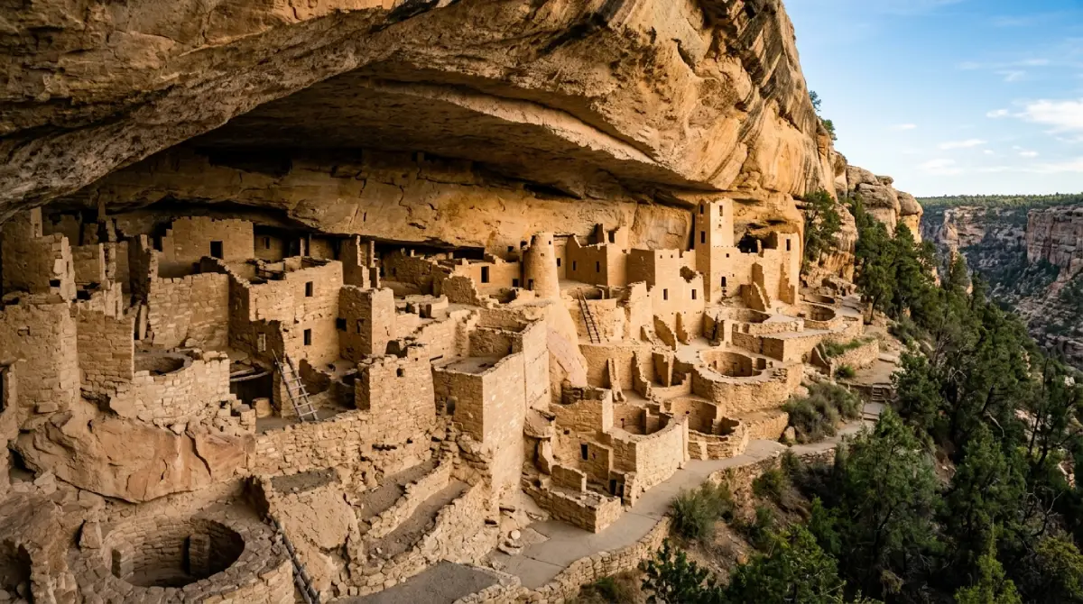
The Four Corners region's cultural significance predates anything in the United States by a thousand years. The Ancestral Puebloan civilization that built Mesa Verde's cliff dwellings between 600 and 1300 CE produced sandstone architecture, road networks, and astronomical alignments that genuinely rival anything in the contemporary world's better-documented civilizations. A Southwest road trip that skips the cultural layer leaves the most distinctive content of the region on the table.
What survives at Mesa Verde:
Mesa Verde National Park preserves over 600 cliff dwellings and 5,000 archaeological sites within its boundaries—the densest concentration of Ancestral Puebloan architecture anywhere. Cliff Palace, the largest cliff dwelling in North America with 150 rooms and 23 kivas, is accessible via ranger-led tours. Balcony House and Long House require similar guided access. The park's mesa-top sites are open to self-guided visits.
The broader cultural network:
Mesa Verde is the most accessible expression of a regional civilization that extended across the Four Corners. Hovenweep National Monument on the Utah-Colorado border preserves stone tower complexes that demonstrate the architectural sophistication. Aztec Ruins in New Mexico shows the largest reconstructed kiva in the country. Chaco Culture National Historical Park—accessible only by 20+ miles of unpaved road—anchors the entire civilizational network with structures aligned to lunar and solar cycles that took centuries to build.
Logistics:
Mesa Verde works as a half-day to full-day stop on a Southwest circuit; budget more if planning multiple guided cliff dwelling tours. Hovenweep is a half-day add. Chaco Canyon's road access requires capable vehicles—the unpaved approaches deteriorate quickly with weather and have stranded standard rentals frequently enough that the National Park Service warns visitors directly. Pack out all waste and respect signed restrictions; these are active cultural sites with descendant communities, not abandoned ruins.
Remote Backcountry: The Optional Expert-Level Extensions
For travelers who want depth beyond the standard circuit, the Southwest's remote backcountry opens up additional layers that most road-trippers never reach.
What the extensions involve:
The Maze District of Canyonlands National Park is the most isolated section of the lower 48 national park system—accessible only via 6+ hours of unpaved driving from the nearest pavement, with no facilities, no cell service, and no rescue infrastructure. The Lockhart Basin road south of Moab parallels Canyonlands' eastern boundary through 60+ miles of remote BLM canyon country. The Burr Trail through Capitol Reef and the Hole-in-the-Rock road descending toward Lake Powell similarly offer multi-day routes through terrain that's genuinely empty.
Vehicle requirement:
High-clearance 4WD with 4LO, full skid plate protection, and recovery gear are baseline. Lockers, larger tires, and self-sufficiency for vehicle issues are appropriate for the more remote routes. These aren't trips for stock vehicles or first-time backcountry drivers regardless of the route's nominal difficulty rating—remoteness creates risk that technical difficulty alone doesn't capture.
The payoff:
The remote backcountry routes deliver the dimension of a Southwest road trip that the popular destinations can't—the genuine sense of empty country, the geology and scale visible without infrastructure to compete with, and the satisfaction of reaching destinations that filtering by capability and commitment.
The Three Gateway Towns: What Each One Delivers
Moab
The Utah anchor of any Southwest road trip and the most concentrated off-road infrastructure in the country. Moab's 5,300 permanent residents support an industry built around 1.8+ million annual visitors and the named trail network surrounding the town.
Services:
Multiple gas stations, full restaurant scene, lodging from camping to luxury, specialized off-road outfitters, and the Cliffhanger Jeep Rentals Moab location. The natural starting or ending point for the Utah leg.
Vibe:
Adventure-tourism focused, busy during peak season (March–May, September–October), and oriented heavily around outdoor recreation rather than general tourism. Plan accommodation 60–90 days out for peak season visits.
Durango
The Colorado leg's primary gateway and the most developed of the Southwest road trip's anchor towns. Sitting at 6,512 feet on the Animas River with established tourist infrastructure dating to the 19th-century mining era, Durango supports a year-round economy that makes it the most flexible base for shoulder-season travel.
Services:
Full services across every category, the Durango & Silverton Narrow Gauge Railroad as a non-driving day option, and the Cliffhanger Jeep Rentals Durango location for road-trippers picking up vehicles for the San Juan technical sections.
Vibe:
Walkable downtown, Fort Lewis College student presence year-round, and the most "real city" feel of any Four Corners stop. Mesa Verde National Park is 35 miles west, putting Durango in the geographic center of the cultural and alpine sections of the trip.
Silverton and Telluride
The high-altitude San Juan towns that anchor the Colorado leg's technical content. Silverton (9,318 feet) provides the most direct access to Animas Forks and the Alpine Loop's technical heart. Telluride (8,750 feet) sits in a box canyon below 13,000-foot peaks with Imogene Pass connecting it directly to Ouray.
Services:
Both towns have full services on a smaller scale than Durango or Moab, with the Cliffhanger Jeep Rentals Silverton and Telluride locations putting capable vehicles within 10 miles of the trailheads. Silverton trends toward 4x4 tourism; Telluride toward upscale resort infrastructure.
Vibe:
Genuinely high-altitude—visitors arriving from sea level should plan acclimatization time before attempting technical alpine driving. Both towns close significantly during shoulder season; confirm seasonal hours and access before planning visits outside peak summer.
Planning Your Southwest Road Trip: Direction, Timing, and Honest Preparation
Direction decision:
The clockwise direction starting in Moab (Utah leg first, Colorado leg second, cultural sites on the return) is generally recommended for travelers arriving via Salt Lake City or Grand Junction. This approach saves the alpine high country for the trip's middle and allows acclimatization to altitude across multiple days. The counter-clockwise direction starting in Durango works for travelers arriving via Albuquerque or the Front Range and prefers the cultural sites as the trip's opening rather than its conclusion.
Timing:
Late May through September is the only window that supports the full circuit including the Colorado high passes. April and October work for Utah and the cultural sites but find most San Juan technical routes still snowed in or already snowed out. Summer (June–August) delivers the longest daylight windows and most reliable trail access but also the heaviest visitor traffic and most aggressive afternoon thunderstorms.
Budget 7–10 days minimum for a representative circuit. The math gets honest quickly: Moab deserves 3 days, the San Juan technical content deserves 2–3 days, Mesa Verde and the cultural sites deserve 2 days, and the driving between regions consumes another full day in each transition. Compressing the circuit below 7 days means choosing which of the three legs to skip rather than fitting all three.
What to bring:
Minimum one gallon of water per person per day; the Southwest's high desert dehydrates faster than most visitors anticipate
Layers spanning 30–90°F; high-altitude mornings and slickrock midday differ by 50°F regularly
Closed-toe footwear with real tread for any walking around canyon edges, slickrock, or cliff dwellings
Offline maps downloaded before departure—cell service drops on most backcountry routes and entirely in remote sections
Recovery gear and basic toolkit for trips including remote backcountry extensions; the standard circuit has enough traffic that help arrives eventually but self-sufficiency is the better plan
Why Cliffhanger for Your Southwest Road Trip
A Southwest road trip's structural challenge is that the destinations defining the region don't match the vehicle most visitors arrive with. National rental brands prohibit off-road use across their fleets, transferring damage liability the moment tires leave pavement. Stock crossovers can't navigate the named trails that justify visiting Moab in the first place. AWD SUVs lack the actual low-range gearing the Colorado high passes require for safe descent. The visitors who fall into those gaps are the ones whose Southwest road trips end as scenic-route summaries of destinations they drove past rather than visited.
Cliffhanger's multi-location footprint exists to close that gap.
What Cliffhanger's regional fleet provides:
Modified Rubicons across Moab, Silverton, Telluride, and Durango locations: drop-off and pickup flexibility that supports the multi-leg structure of a real Southwest road trip
2.5-inch lift with 35-inch aggressive tires: clearance and grip for slickrock, alpine scree, and the unpaved approaches to cultural sites that stock vehicles can't handle
Extreme Rubicons with 3.5-inch lift and 39-inch tires: the configuration for Black Bear Pass, Lockhart Basin, the Maze District, and the optional expert-level extensions
Full skid plate protection and 4LO low-range capability: the actual hardware that the named technical routes require, not the AWD AUTO modes that fail on the descents
Trail-permission contracts with damage and recovery terms structured around real off-road use rather than excluding it
A Southwest road trip is one of the defining adventures available in the United States. It rewards proper preparation with sandstone canyons, ghost-town alpine passes, thousand-year-old cliff dwellings, and the high desert scenery that puts this corner of the country in the same conversation as anywhere on the continent. It also creates consistent disappointment for travelers who arrived in vehicles that prohibited the destinations they came for.
Cliffhanger exists to make sure your trip falls in the first category.
Ready to drive a Southwest road trip in a vehicle built for every leg of it? Contact Cliffhanger Jeep Rentals at any of our Four Corners locations and let's put together the configuration that makes the trip what it's supposed to be.