What Nobody Tells You Before You Drive the Shafer Trail Moab
Here's what the Canyonlands brochures conveniently omit about the Shafer Trail Moab: the dramatic switchback section that defines the route descends 1,500 vertical feet of unpaved cliff face in roughly two miles of tight single-lane turns with no guardrails, the trail closes without warning the moment rain hits the clay surface and turns it into a sliding hazard that has killed before, and the rental SUV that the National Park Service approved at the Island in the Sky entrance station is almost certainly contractually prohibited from driving the road its own park ranger directed visitors toward.
The Shafer Trail isn't a scenic drive with a couple of rough patches. It's a working backcountry route built by cattle ranchers in the early 1900s, widened into a uranium hauling road during the 1950s boom, and now functioning as the most dramatic legal vehicle access from the Island in the Sky mesa top into the broader Canyonlands canyon system. The route delivers panoramic exposure that has put the switchback section into Utah tourism marketing for fifty years, accesses the White Rim Road network that supports multi-day backcountry trips through one of the most remote sections of the lower 48, and connects via Potash Road back to Moab through one of the most underrated scenic corridors in the region.
Tens of thousands of visitors attempt the Shafer Trail each year. The ones who get the most out of it—and avoid the rollover photographs that periodically circulate on Moab social media after rental SUVs misjudge the switchbacks—are the ones who arrive with the right vehicle, the right information, and an honest understanding of what the descent actually demands.
Shafer Trail Moab at a Glance
Total distance: 18 miles from the Island in the Sky entrance to Potash Road; 4 miles for the dramatic switchback section alone
Elevation drop: Approximately 1,500 feet from the Island in the Sky mesa top to the canyon floor below
High point: 6,200 feet at the Island in the Sky trailhead; 4,000 feet at the canyon floor
Park status: Inside Canyonlands National Park for the upper section; transitions to BLM land at the White Rim junction
Typical season: Year-round when conditions are dry; closed without notice during and after rain or snow
Drive time: 2–3 hours one-way with stops; full Shafer-to-Moab loop via Potash Road takes 4–6 hours
Vehicle requirement:
High-clearance 4WD with low-range gearing strongly recommended; 2WD permitted in dry conditions but consistently produces the recovery calls that close the trail
What it covers:
The Shafer Trail's defining section is a series of tight switchbacks descending the cliff face below the Island in the Sky mesa—the photograph that sells the trail and the engineering that makes the descent possible. Below the switchbacks, the route flattens onto a broad bench at approximately 4,800 feet before continuing to the junction with the White Rim Road and Potash Road. The lower section follows the Colorado River corridor through dramatic canyon country, passes the Potash evaporation ponds (the unexpectedly photogenic turquoise pools that show up on Moab Instagram feeds without context), and connects back to Moab via Highway 279.
Designated status:
The upper Shafer Trail sits within Canyonlands National Park boundaries; standard entrance fees and park regulations apply. The lower sections cross BLM land where regulations differ. The White Rim Road continuation requires day-use or overnight backcountry permits managed through the National Park Service. The Shafer Trail itself does not require advance permits for day use, but the entrance station at Island in the Sky collects standard park admission.
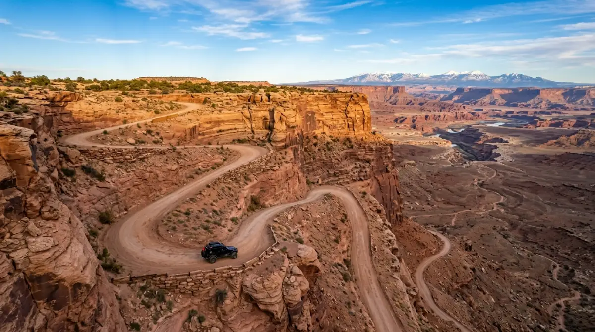
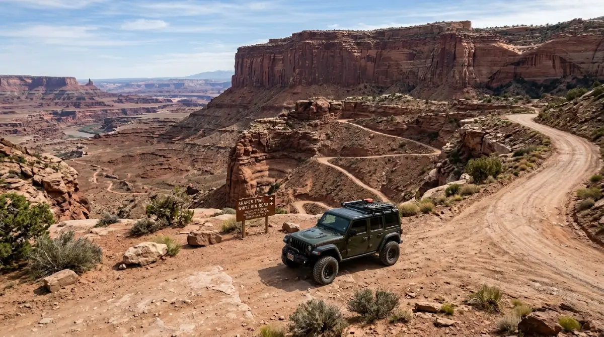
The Switchbacks: The Trail's Defining Feature
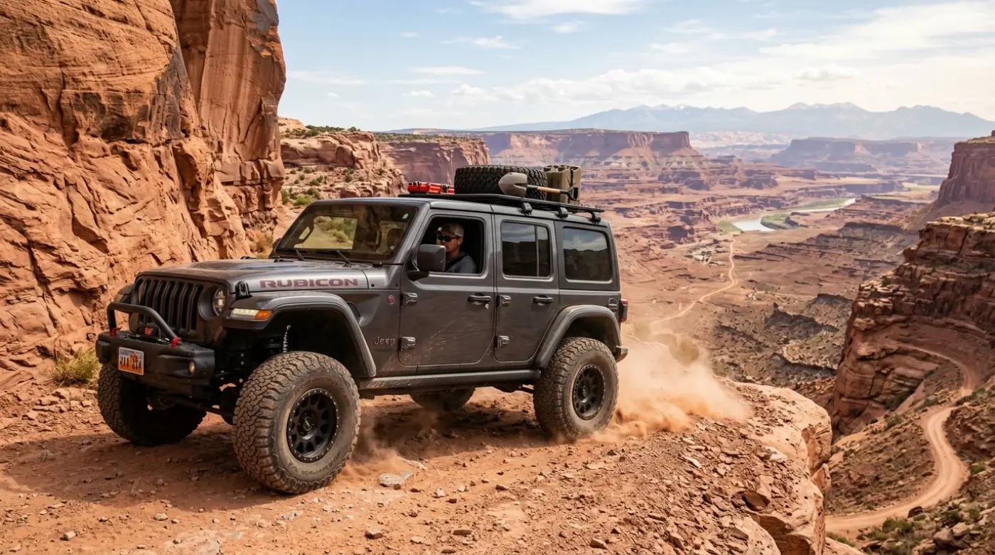
The Shafer Trail switchbacks are the photograph that brings most visitors to the route and the engineering that makes the descent into Canyonlands' lower districts physically possible. Carved into the cliff face below the Island in the Sky mesa, the switchback section drops roughly 1,500 vertical feet over 2 miles of single-lane unpaved turns with exposure that creates genuine risk for inattentive driving.
What the descent delivers:
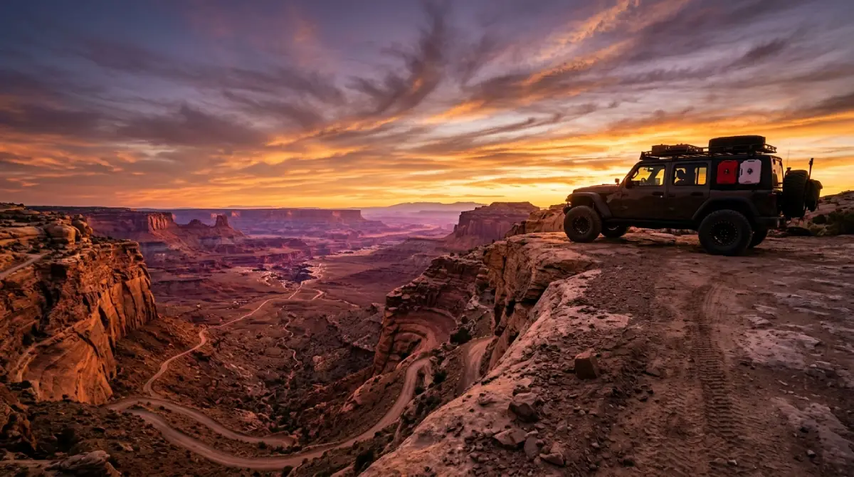
From the Island in the Sky trailhead, the road approaches the cliff edge through pinyon-juniper terrain before the descent begins at a marked overlook. The first switchback delivers an immediate visual reset—the canyon floor 1,500 feet below, the White Rim sandstone bench stretching to the horizon, and the road itself visible as a thin line of switchbacks carved into the cliff face below. Most casual visitors stop at this overlook and never make the descent; the views available without dropping into the canyon are genuine, but the experience of running the switchbacks is fundamentally different from photographing them from above.
The technical reality:
The switchbacks themselves are single-lane shelf road with intermittent wide spots where opposing traffic can pass. The road surface transitions between hard-packed dirt, exposed slickrock, and loose rocky sections. Tight turns require careful steering on the inside line; aggressive approaches to blind switchbacks create the close calls and occasional accidents that periodically force the trail closed for recovery operations.
The clay closure reality:
The Shafer Trail's surface contains significant clay content that becomes dangerously slick when wet. The Park Service closes the trail without notice during and after precipitation, with closures typically lasting 24–72 hours depending on conditions. Drivers who ignore closure signs or attempt the trail in marginal conditions consistently provide the recovery calls and search-and-rescue incidents that make the trail's news coverage.
Technical specifics:
The switchback section is rated easy-to-moderate in dry conditions, dangerous-to-impassable when wet
Single-lane sections require backing to the nearest wide spot when meeting opposing traffic; uphill traffic generally has right of way, but courtesy and visibility determine the actual yielding pattern
4LO engagement strongly recommended on the descent; engine braking on the sustained grade provides control that service braking alone struggles to match
Cell service is nonexistent throughout the switchback section and most of the lower trail; download offline maps and communicate the planned route before departure
The White Rim Junction and the Lower Shafer
Below the switchback section, the Shafer Trail flattens onto a broad bench and connects to the White Rim Road network at a marked junction. The lower trail continues from this junction toward Potash Road and Moab, traversing some of the most underrated scenery in the Canyonlands corridor.
The route from the junction:
Heading toward Moab from the White Rim junction, the Shafer Trail follows the broad bench above the Colorado River through a section of high desert that most visitors never see. Massive red rock formations rise on both sides of the route, the Colorado River appears intermittently below, and the scale of the canyon system becomes apparent in a way that overlook photography can't capture.
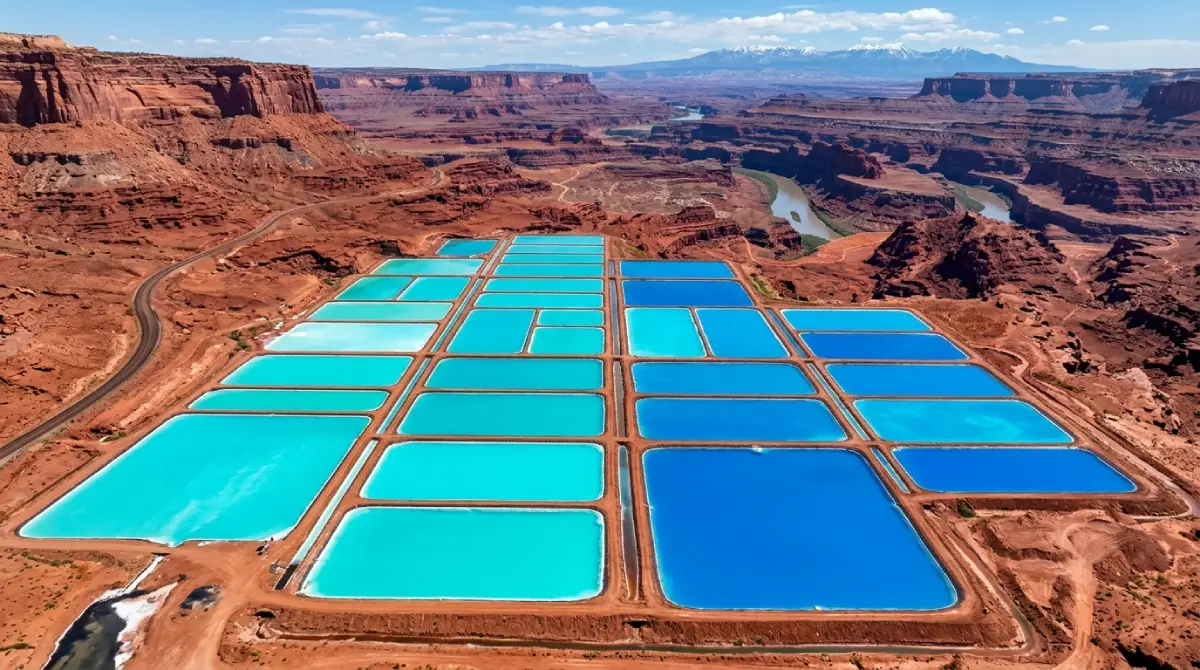
The Potash transition:
The Shafer Trail terminates at Potash Road (BLM Road 279), which continues into Moab. The transition point passes the Intrepid Potash evaporation ponds—a series of bright turquoise mining ponds used to extract potash from underground deposits. The color is genuine and unexpected; the ponds appear on Moab social media without context as often as the switchback section above.
Thelma & Louise context:
The final scene of the 1991 film Thelma & Louise was filmed on the cliffs above the Shafer Trail corridor, with the actual filming location near the head of the switchbacks. Cinephiles making the trip occasionally request to identify the specific overlook; the spot is documented in Moab tour guide literature and accessible via short side trips from the main route.
Technical specifics:
The lower Shafer Trail past the White Rim junction is easier than the switchback section; high-clearance 2WD is sufficient in dry conditions for most drivers
Sandy washes intersect the route in multiple locations; deeper soft sand favors 4WD with momentum, particularly in summer when surfaces dry out completely
Potash Road (BLM 279) from the trail terminus to Moab is paved and accessible to any vehicle
Cell service returns approximately 5 miles before Moab on the Potash Road section
The History: Cattle, Uranium, and the Modern Trail
The Shafer Trail's transition from cattle path to uranium haul road to modern recreational trail spans roughly 110 years of Western development history. Each phase left infrastructure and routing decisions still visible to drivers attentive to the layered evidence.
The cattle ranching origin:
The trail takes its name from Frank and John Shafer, ranchers who established the route in the early 1900s as a way to move cattle between the Island in the Sky mesa top and the canyon floor below. The original Shafer Trail was a pack route rather than a vehicle road—too narrow for wagons, too steep for most stock, but adequate for experienced ranchers moving cattle through terrain that had no other access. The Shafer brothers' operation eventually failed, defeated by the same isolation and water scarcity that limited every cattle operation in the canyon country.
The uranium boom transformation:
The 1950s uranium boom rebuilt the Shafer Trail as a vehicle road capable of supporting ore trucks descending from claims on the mesa top to the lower canyon system. The road's modern alignment, including the switchback engineering that defines the visitor experience, dates to this period. The uranium boom ended within a decade, but the road improvements survived—creating the infrastructure that makes modern recreational use possible.
The Park Service era:
When Canyonlands National Park was established in 1964, the Shafer Trail's upper section came under National Park Service jurisdiction. The agency maintains the road for vehicle access while managing it as a primitive backcountry route rather than a developed park drive. Closure protocols, surface maintenance, and rescue infrastructure all reflect the road's status as a serious backcountry asset rather than a tourist scenic drive.
The White Rim Road: The Optional Expert-Level Extension
For drivers who complete the Shafer Trail and want more, the White Rim Road extends the experience into a multi-day backcountry expedition through the heart of Canyonlands' middle district.
What it involves:
The White Rim Road follows the broad sandstone bench between the Island in the Sky mesa top and the Colorado and Green Rivers below, completing a 100-mile loop through some of the most remote backcountry in the lower 48 national park system. The route connects to the Shafer Trail at the top and the Mineral Bottom switchbacks at the western end, with multiple campsites distributed along its length for multi-day touring.
Vehicle requirement:
High-clearance 4WD with 4LO low-range capability, aggressive all-terrain tires, and full skid plate protection are baseline expectations for the White Rim. Recovery gear and self-sufficiency for vehicle issues are appropriate given the route's remoteness and limited rescue infrastructure. Stock vehicles and AWD crossovers consistently get into trouble on the White Rim—the Park Service maintains a public record of recovery operations that supports the case for proper vehicles.
The permit reality:
The White Rim Road requires advance permits for both day use and overnight backcountry use, with permits typically reserved 3–4 months in advance through the National Park Service. The Shafer Trail itself does not require these permits, but the moment a vehicle passes the White Rim junction and continues along the rim road, permit requirements apply. Confirming permit status before departure is non-negotiable; rangers actively enforce the requirement.
The payoff:
The White Rim's two-to-three-day touring experience delivers depth that the Shafer Trail alone can't approach—the genuine remoteness of canyon country, the geology and scale visible without competing infrastructure, and the satisfaction of completing one of the lower 48's most significant backcountry vehicle routes.
Three Ways to Drive the Shafer Trail: What Each One Delivers
Top-Down From Island in the Sky
The standard approach descends from the Island in the Sky entrance through the switchback section to the canyon floor below. Most first-time visitors choose this direction; the descent provides the route's most dramatic visual impact and the easier driving direction on the switchback grade.
Logistics:
Pay the Canyonlands entrance fee at Island in the Sky, drive to the Shafer Trail overlook, and begin the descent. The route exits at Potash Road and returns to Moab via Highway 279.
The trade-off:
Top-down driving means the most exposed sections of the switchbacks face the driver as the descent begins—a psychological reality that affects some drivers more than others. The descent direction provides better visibility into the switchback turns, which is generally the safer orientation for first-time visitors.
Bottom-Up From Potash Road
The reverse direction ascends from Potash Road through the lower trail to the switchback section, climbing the 1,500 vertical feet to the Island in the Sky mesa top. Less commonly chosen, but the preferred direction for some experienced drivers.
Logistics:
Start at Potash Road from Moab, ascend through the lower trail, and climb the switchbacks to Island in the Sky. The Canyonlands entrance fee applies on exit if the vehicle continues into the park proper.
The trade-off:
Bottom-up driving puts the vehicle on the inside lane of switchbacks (toward the cliff rather than the drop-off), which most drivers find psychologically easier. The climb requires more power from the vehicle than the descent does and tests cooling system capacity in summer heat.
As Part of a White Rim Multi-Day
The Shafer Trail integrated into a White Rim Road expedition makes the route the entrance or exit of a 100-mile backcountry loop rather than a standalone drive. The most committed version of the Shafer experience.
Logistics:
White Rim permits required for the multi-day component. The Shafer entrance from Island in the Sky and exit via Mineral Bottom (or vice versa) make a complete loop with the full White Rim distance.
The trade-off:
The White Rim addition transforms the trip from a half-day outing into a 2–4 day backcountry expedition. Vehicle capability, self-sufficiency, and planning requirements all scale accordingly. The payoff is among the most significant backcountry experiences available in the national park system.
Driving the Shafer Trail: Direction, Timing, and Honest Preparation
Direction decision:
The top-down direction from Island in the Sky is generally recommended for first-time visitors. Better descent visibility, easier driving on the switchback grade, and the option to abort and return uphill if conditions or driver confidence change. The bottom-up direction works for experienced drivers and for combinations with the White Rim Road that route logically from Potash Road through the Shafer ascent.
Timing:
Start early during summer months. Slickrock and exposed dirt surfaces above 4,000 feet heat aggressively after 10 AM, and afternoon thunderstorms can develop quickly during monsoon season (July through September). Be off the switchback section before noon when precipitation is forecast within 24 hours.
The trail is accessible year-round in dry conditions. Winter use is genuine—the trail sees regular visitors November through March—but ice forms in shaded sections and snow can accumulate quickly with frontal storms. Spring and fall provide the optimal balance of temperature, surface conditions, and visitor traffic patterns.
What to bring:
Minimum one gallon of water per person; the lower trail's elevation and exposure increase dehydration rates significantly
Sun protection regardless of season; canyon-floor glare is intense even in winter conditions
Closed-toe footwear with real tread for any walking near the switchback overlooks or canyon edges
Offline maps downloaded before departure; cell service is nonexistent throughout most of the trail
Recovery straps and a basic toolkit for self-sufficiency on the lower trail sections
Weather check immediately before departure; the trail closes without notice during precipitation, and arriving at a closed gate eliminates the day
Why Cliffhanger for the Shafer Trail Moab
The Shafer Trail's combination of dramatic exposure, surface variability, and weather-dependent closure status separates it from casual scenic drives clearly and early. The switchback section is genuinely accessible to high-clearance 2WD in dry conditions—but the rental SUVs that visitors typically arrive with prohibit unpaved use entirely, transferring damage liability onto the renter the moment the tires leave pavement. The White Rim extension demands genuine off-road capability that stock vehicles can't provide regardless of contract terms.
Cliffhanger's Moab location is the natural starting point for the Shafer Trail done right.
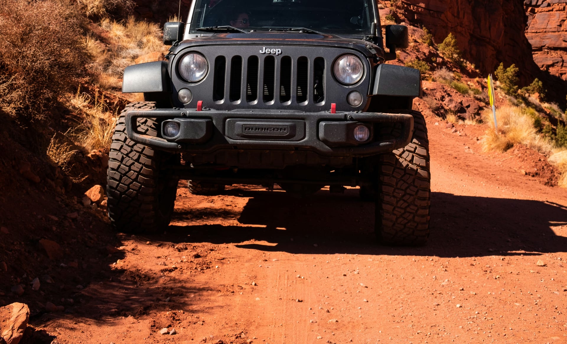
What Cliffhanger's Moab Rubicons provide:
2.5-inch lift with 35-inch aggressive tires: clearance and grip for the switchback surfaces and lower trail variability that challenge stock vehicles
Extreme Rubicons with 3.5-inch lift and 39-inch tires: the configuration for full White Rim multi-day extensions and the optional expert-level Canyonlands backcountry routes
Full skid plate protection: oil pan, transmission, and transfer case coverage that turns rock contact into a non-event rather than a trip-ending damage moment
4LO low-range capability: the actual low-range gearing that the switchback descent and any technical extension requires—not the AWD AUTO modes that provide neither the control nor the engine braking that matters
Trail-permission contracts: explicit authorization for the Shafer Trail, Potash Road, and the connected backcountry routes, with damage and recovery terms structured around real off-road use
Local staff with current conditions: trail status changes with weather; Moab-based staff know the Shafer's current state before you head out
The Shafer Trail Moab is one of the defining vehicle access routes in the national park system. It rewards proper preparation with switchback engineering, panoramic canyon overlooks, the White Rim corridor, and the desert scenery that puts this corner of Utah in the same conversation as anywhere on the Colorado Plateau. It also creates consistent rental damage disputes and recovery operations from vehicles and drivers that arrived unprepared.
Cliffhanger exists to make sure your trip falls in the first category. Ready to drive the Shafer Trail Moab in a vehicle built for every section of it? Contact Cliffhanger Jeep Rentals in Moab and let's put together the configuration that makes the descent what it's supposed to be.