Here's what the scenic byway brochures conveniently omit about Potash Road Moab: the jarring transition where smooth pavement ends at mile 16.5 and the next 19 miles require legitimate 4x4 capability, the Shafer Trail switchbacks that climb 1,500 vertical feet on single-lane shelf roads with exposure that makes passenger knuckles turn white, and the harsh reality that "scenic drive" transforms into "technical backcountry route" the moment you pass the potash mining facility.
Potash Road isn't just "another pretty drive with an optional 4x4 extension." It's Utah Highway 279—a 17-mile paved scenic byway that delivers genuine accessibility alongside the Colorado River, followed by a decision point where tourists either turn around satisfied with petroglyphs and Corona Arch, or commit to 19 additional miles of unpaved terrain that demand vehicles genuinely built for what comes next.
The statistics tell an uncomfortable story: Moab search-and-rescue teams respond to an average of 127 backcountry vehicle incidents annually, with recovery costs averaging $1,847 per incident. A significant percentage involve tourists who successfully navigated Potash Road's paved section, then assumed the continuation would maintain the same character. The difference between experiencing Potash Road completely versus turning around at the pavement's end fundamentally depends on vehicle capability and honest self-assessment.
Understanding Potash Road's Two Distinct Characters
The confusion about Potash Road stems from treating it as a single experience when it's actually two completely different routes sharing the same name.
Potash Road: The Paved Scenic Byway (Miles 0-16.5)
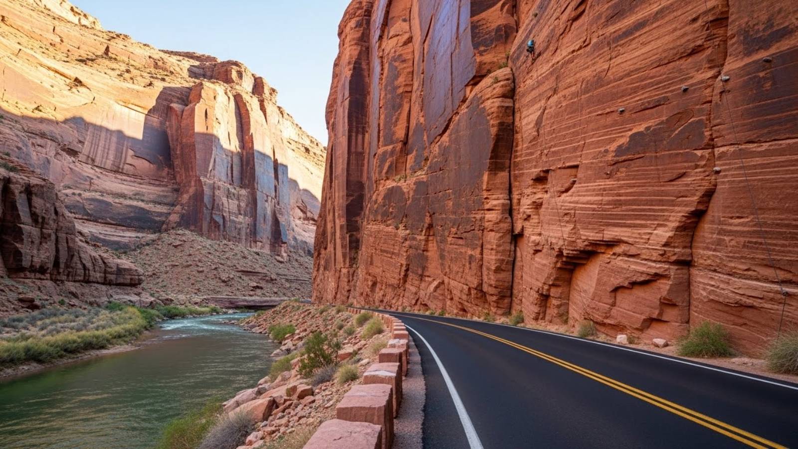
The paved section—officially Utah Scenic Byway 279—starts at the junction with US Highway 191 approximately three miles north of Moab. This 17-mile section provides genuine accessibility for any vehicle type, delivering spectacular scenery without technical driving demands.
Paved section characteristics:
Complete accessibility
- Standard sedans, RVs, motorcycles, and road bicycles handle this section confidently. No ground clearance concerns, no 4WD requirements, no technical obstacles.
Continuous scenery
- The road immediately drops alongside the Colorado River, squeezing between towering Navajo sandstone cliffs on the right and the river on the left. The canyon walls reach 1,000+ feet in places, creating the dramatic "Wall Street" section beloved by rock climbers and photographers.
Multiple attractions
- Petroglyphs visible from pullouts (ancient rock art panels featuring bighorn sheep, hunters, and geometric patterns), dinosaur tracks requiring short hikes up sandstone slopes, Corona Arch trailhead (3-mile roundtrip moderate hike to spectacular 140-foot-wide arch), Jug Handle Arch visible from the road at mile 13.5.
No services
- Zero gas stations, zero food options, zero restrooms beyond the occasional vault toilet at trailheads. Cell service fades completely after mile 5.
Popular with cyclists
- The flat, paved surface attracts serious road cyclists who appreciate smooth asphalt through spectacular canyon scenery without traffic concerns.

The paved section ends at the Moab Potash Plant (also called the Intrepid Potash facility) where potassium chloride is extracted through evaporation ponds that appear bright blue from the dye added to accelerate the 300-day evaporation process. Most tourists appropriately stop here, satisfied with the accessible scenic experience just completed.
Potash Road: The Unpaved 4x4 Extension (Miles 16.5-35+)
Beyond the potash plant, the road transforms completely. Pavement ends. Traffic density drops dramatically. Vehicle requirements shift from "anything with wheels" to "high-clearance 4WD recommended, 4LO capability preferred."
Unpaved section characteristics:
Technical terrain
- Deep sand sections alternate with embedded rock gardens, high centers that scrape undercarriages, and washboard surfaces that shake vehicles relentlessly. The road deteriorates significantly after rain, creating mud sections that trap inadequate vehicles.
Shafer Trail connection
- The unpaved Potash Road connects to Shafer Trail approximately 7 miles past the plant. This junction presents the next decision point—continue on relatively moderate terrain toward White Rim Road, or commit to Shafer Trail's 1,500-foot climb via switchbacks.
Exposure sections
- The Shafer Trail switchbacks feature single-lane shelf roads carved into near-vertical sandstone cliffs. The outside edge drops hundreds of feet with minimal margin for error. Meeting opposing traffic requires one vehicle to carefully back up to the nearest wide spot.
Famous filming location
- The "Thelma & Louise Point" (officially Gooseneck Overlook) marks where the 1991 film staged its iconic final scene. The view reveals the Colorado River's dramatic horseshoe bend far below.
Canyonlands access
- Shafer Trail provides backdoor access to Canyonlands National Park's Island in the Sky district, emerging near the visitor center after climbing those 1,500 vertical feet. This creates a spectacular loop possibility—enter Canyonlands via paved Highway 313, descend Shafer Trail, exit via Potash Road back to Moab.
3-4 hour minimum
- The unpaved extension from potash plant to Canyonlands visitor center typically requires 3-4 hours of careful driving, depending on stops, traffic, and vehicle capability. This isn't casual sightseeing—it's committed backcountry travel.
The Wall Street Section: Moab's Roadside Climbing Gallery
Between miles 2-3 on Potash Road, the canyon narrows dramatically as the road squeezes between river and cliff. This section—nicknamed "Wall Street"—hosts Moab's most accessible rock climbing, where hundreds of established routes cover sandstone walls rising 800+ feet directly from the road.
Pull into any of the paved parking bays and watch climbers working routes with names like "Knapping with the Alien," "Morning Thunder," and "30 Seconds Over Potash." The convenience factor makes this unusual—world-class climbing accessible without hiking approaches, where spectators park literally at the base of multi-pitch routes.
Corona Arch: Potash Road's Hiking Highlight
At mile 10, a signed parking area marks the trailhead for Corona Arch—a 3-mile roundtrip moderate hike that delivers one of Moab's most impressive arch formations. Corona Arch spans 140 feet wide and stands 100 feet tall, creating an opening large enough to frame helicopters that occasionally fly through for dramatic photography.
The trail characteristics:
Technical sections: The route includes sections of slickrock (requiring painted trail markers to follow), cable-assisted climbs up sandstone slopes, and exposure near the arch itself. Most moderately fit hikers complete it successfully, but it's genuinely more challenging than casual nature walks.
1.5 hours roundtrip: Budget 90 minutes minimum, longer with extended photo sessions at the arch. The approach provides varied terrain and several smaller arches (Bowtie Arch) along the way.
Timing considerations: Summer heat makes afternoon hikes punishing—start early or save for evening when temperatures moderate. Spring and fall provide optimal conditions.
Corona Arch doesn't require permits or fees beyond Potash Road access, making it popular with visitors seeking impressive formations without Arches National Park crowds. The combination of dramatic size and relative accessibility explains why it's become a Moab favorite despite requiring a genuine hike.
Petroglyphs and Dinosaur Tracks: Ancient History Visible from the Road
Potash Road provides remarkable access to both Native American rock art and actual dinosaur footprints—experiences that usually require significant hiking elsewhere in the Moab area.
Petroglyphs (Mile 5.5):
Look for the brown "Indian Writing" sign and small pullout. Dark desert varnish on the cliff face holds dozens of ancient carvings—bighorn sheep, human figures, geometric spirals, and mysterious symbols created by ancestral Puebloan peoples roughly 1,000 years ago.
The carvings sit high on the wall, making binoculars helpful for detailed viewing. The convenience factor again stands out—walk 20 feet from your vehicle to observe rock art that's survived a millennium while facing the Colorado River.
Dinosaur Tracks (Mile 7):
Shortly past the petroglyphs, another signed pullout provides access to fossilized dinosaur tracks embedded in slickrock approximately 100 yards upslope from the road. The short hike includes some scrambling and modest exposure, but the payoff reveals multiple three-toed theropod tracks approximately 150 million years old.
Two track locations exist at different elevations on the slope. The lower trackway shows at least 10 different meat-eating dinosaurs ranging from 17 inches to 5 feet tall at the hip, all apparently walking at similar speeds (approximately 3 mph based on stride analysis). Additional petroglyphs appear near the upper track site, combining prehistoric footprints with historic rock art in the same location.
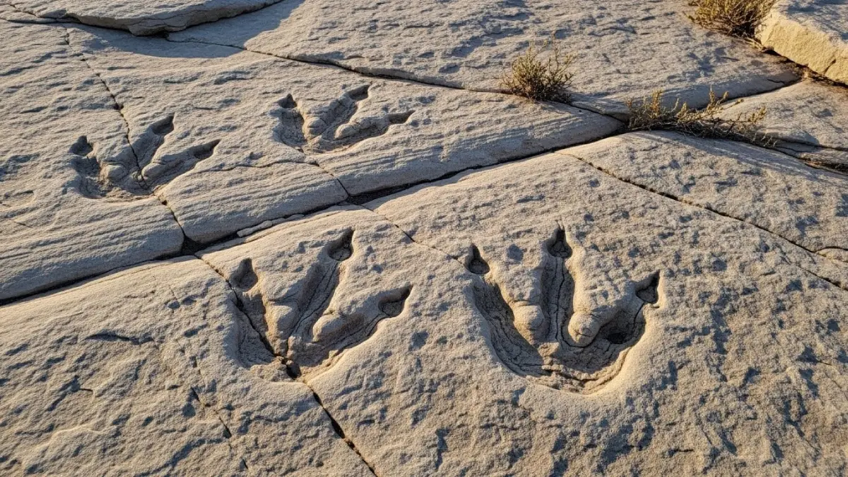
The preservation quality varies with lighting—early morning or late afternoon side lighting reveals track details invisible during midday. Bring water for even this short off-road excursion, as summer heat intensifies quickly away from the river.
The Shafer Trail Decision Point: Where Capability Becomes Critical
The junction where Potash Road dirt section meets Shafer Trail presents the crucial decision that separates confident exploration from potential expensive mistakes. Understanding what Shafer Trail actually demands helps make this choice rationally rather than optimistically.
Shafer Trail specifications:
19 miles unpaved: From the Potash junction to Canyonlands visitor center, expect varied dirt conditions ranging from maintained gravel to embedded rock, deep sand pockets, and sections requiring careful line selection.
1,500-foot elevation gain: The famous Shafer switchbacks climb the canyon wall in a series of tight zig-zags carved into near-vertical sandstone. This isn't gradual climbing—it's sustained, technical ascent with constant attention required.
Single-lane shelf road: Multiple sections provide room for only one vehicle width, with sheer cliff exposure on the outside edge. Meeting opposing traffic requires backing to the nearest wide spot, which might be hundreds of yards distant.
High-clearance 4WD recommended: The National Park Service officially recommends high-clearance 4WD vehicles with low-range gearing (4LO capability). This isn't legal requirement—it's practical advice based on consistent incident patterns.
Variable conditions: Recent rain transforms sections to slick mud. Dry conditions create dusty visibility challenges. Strong winds create crosswind concerns on exposed sections. Morning ice in spring/fall makes early starts dangerous.
2.5-4 hour drive time: The 19-mile distance suggests quick travel, but rough surfaces, switchback navigation, photo stops, and traffic encounters extend actual driving time significantly. Budget half a day minimum for the complete experience.
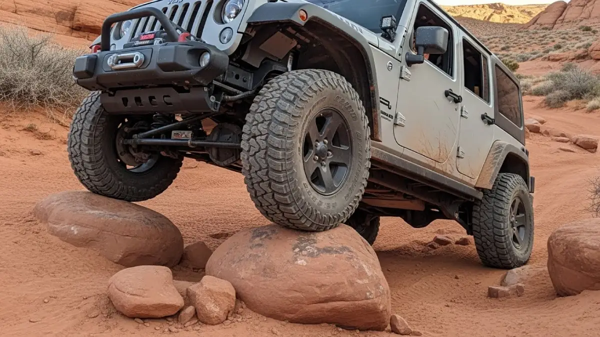
Tourists consistently underestimate Shafer Trail's demands. The successful completion of Potash Road's easy paved section creates false confidence about what comes next. The vehicles they're driving—rental SUVs, crossovers, even some stock 4x4s—lack the clearance, protection, and suspension articulation that confident Shafer navigation requires.
The Vehicle Capability Gap
The progression from paved Potash Road to unpaved Shafer Trail creates a vehicle requirement jump that catches tourists consistently. Understanding the specific mechanical differences between adequate and inadequate vehicles prevents those $1,847 average recovery costs.
Stock rental SUVs on Shafer Trail:
Most rental companies explicitly prohibit off-pavement driving. Their insurance doesn't cover damage from unpaved roads, meaning that cracked oil pan or bent control arm becomes your financial responsibility despite "4WD" badges.
Ground clearance problems: 8-9 inches typical for crossover SUVs versus 11-14 inches needed for confident Shafer navigation. That 3-5 inch gap means constant undercarriage contact concerns, slow speeds over obstacles, and genuine risk of serious damage on high centers.
Approach/departure angle limitations: Stock vehicles have bumpers designed for aesthetics, not clearance. Steep Shafer sections create front and rear contact that damages plastic bumper covers, drags exhaust systems, and tears off decorative elements.
Inadequate tire selection: Highway all-season tires provide zero grip on sand, limited bite on embedded rock, and sidewalls that puncture easily from sharp sandstone edges. The combination creates both traction and reliability problems.
No underbody protection: Oil pans, transmission cases, transfer cases, and fuel tanks hang vulnerable on stock vehicles. One solid contact can crack an oil pan, and the subsequent leak strands you miles from help.
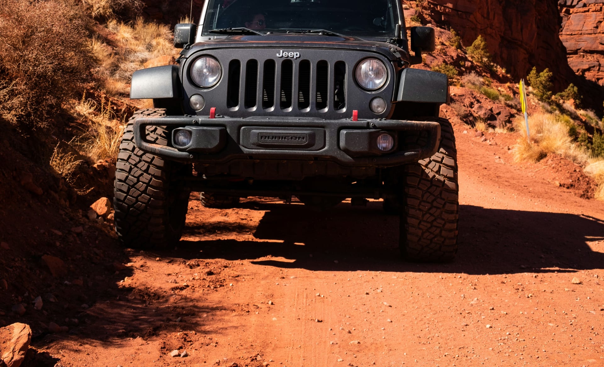
Cliffhanger Modified Rubicons:
Our modified Jeeps start with the Rubicon platform (already significantly more capable than standard Wranglers), then add the specific enhancements that Potash-Shafer loops demand:
2.5-3.5 inch suspension lifts: 11.5-13+ inches ground clearance depending on model, creating margin over every high center and embedded rock that challenges stock vehicles.
35-39 inch aggressive tires: Larger diameter for obstacle clearance, reinforced sidewalls for puncture resistance, aggressive tread for sand and rock traction. We run appropriate pressures for conditions—aired down for sand sections, higher for rock gardens.
Complete skid plate protection: Heavy-duty steel covers protecting oil pan, transmission, transfer case, and gas tank. Contact with obstacles becomes normal driving rather than damage events.
Improved approach/departure angles: Steel bumpers designed for clearance rather than aesthetics, creating the angles that steep Shafer sections require without damage.
Recovery equipment included: Tow straps, shackles, and proper recovery points. When (not if) you need to help another stuck vehicle, or when trail conditions exceed expectations, proper gear becomes essential.
The mechanical capability gap isn't subtle. It's the difference between constant worry versus confident driving, between "will I make it?" versus "which line looks more fun?", between expensive damage versus normal use of vehicles designed for exactly this terrain.
Planning Your Complete Potash Road Experience
Successful Potash Road adventures start with honest capability assessment and appropriate preparation matching your actual vehicle and skill level.
For the Paved Section Only (Any Vehicle):
Budget 2-3 hours for the 17-mile paved section with stops at Wall Street, petroglyphs, dinosaur tracks, and Corona Arch trailhead. Start early to beat summer heat if hiking Corona Arch. Bring water, snacks, and sun protection despite the "short scenic drive" designation. Cell service fades quickly—download offline maps before leaving Moab. Fuel up completely in town, as services don't exist on Potash Road.
Consider morning or evening visits for optimal photography lighting. The east-facing canyon walls glow dramatically during sunrise, while afternoon light creates deep shadows that emphasize cliff textures.
For the Complete Loop (High-Clearance 4WD Required):
The full Potash-Shafer-Canyonlands loop requires all-day commitment: 6-8 hours minimum including driving, stops, and park exploration. This isn't casual sightseeing—it's committed backcountry travel demanding appropriate preparation.
Essential preparations:
Vehicle verification
- Confirm your rental agreement explicitly permits unpaved road travel. Most major rental companies prohibit it. Verify adequate ground clearance (11+ inches minimum), 4WD capability with low-range gearing, and proper tire condition/pressure.
Weather monitoring
- Check forecasts carefully. Afternoon thunderstorms create flash flood risk in the canyon sections. Rain makes the Shafer switchbacks extremely slippery. Strong winds make exposed sections dangerous. Winter ice makes early starts inadvisable.
Emergency supplies
- Extra water (1 gallon per person minimum), emergency food, first aid kit, flashlight/headlamp, warm layer even in summer (nighttime temperatures drop significantly), and basic tools. Cell service is nonexistent throughout most of the route.
Timing considerations
- Start early (7-8 AM) to complete before afternoon heat peaks and summer storms develop. The loop typically takes 6-8 hours, so late starts risk finishing in darkness. Shafer switchbacks become genuinely dangerous in low-light conditions.
Park entrance
- Canyonlands National Park charges $30 per vehicle (7-day pass) or accepts America the Beautiful annual passes. No timed entry requirements currently, but check current conditions as policies change.
Direction decision
- Most drivers prefer descending Shafer Trail (starting in Canyonlands, exiting via Potash) rather than climbing it. Descending provides better sightlines around blind corners and feels psychologically easier despite similar technical demands. However, starting via Potash Road provides graduated difficulty increase—easy paved section, moderate unpaved section, then technical Shafer Trail. Choose based on your comfort level with exposure and steep grades.
Why Proper Vehicle Selection Changes Everything
The difference between experiencing Potash Road's complete loop confidently versus constantly worrying about damage or capability fundamentally changes the adventure quality. This explains why Cliffhanger's modified Jeeps transform what might be white-knuckle stress into genuine exploration.
Confidence on technical sections: When your vehicle provides 12+ inches clearance with proper protection, high centers and embedded rocks become normal driving rather than damage threats. You focus on line selection for fun rather than constant worry about undercarriage contact.
Actual 4LO capability: Low-range gearing provides the control that technical descents and steep climbs demand. Engine braking on Shafer switchbacks, precise crawling over obstacles, and momentum management in sand all require genuine 4LO—not just "4WD AUTO" modes that many crossovers offer.
Suspension that articulates: Keeping all four tires in contact with irregular terrain requires suspension travel that stock vehicles don't provide. Three-wheel scenarios (one tire lifted) shift weight unpredictably and reduce traction exactly when you need it most.
Proper recovery capability: When you inevitably encounter stuck vehicles (or when your own line selection proves optimistic), proper recovery equipment and solid mounting points become essential. Cliffhanger vehicles include appropriate gear because backcountry travel makes it mandatory.
The Cliffhanger Advantage for Potash-Shafer Loops
Potash Road from pavement to Canyonlands represents exactly what Cliffhanger Jeeps handle best—accessible scenic driving combined with genuine technical sections that demand capability. Our modified Rubicons provide the specific equipment that this route requires while eliminating the rental restrictions that prevent using standard vehicles.
Our Moab location positions you minutes from Potash Road's start, with local staff providing current conditions information and realistic time estimates. Our vehicles come equipped with appropriate recovery gear, proper tire pressures preset for conditions, and the confidence-inspiring capability that transforms anxiety into adventure.
The investment makes sense mathematically: our modified Rubicon daily rates deliver purpose-built vehicles versus standard rental SUVs that cost similar amounts while explicitly prohibiting the driving you're planning. Factor recovery costs ($1,847 average) and potential damage responsibility (thousands more), and proper equipment becomes obviously cost-effective.
Experience Potash Road's Complete Character
Potash Road from paved scenic byway to technical Shafer Trail connection represents Moab's accessibility-to-adventure spectrum compressed into single experience. The 17 miles of pavement deliver genuine beauty without capability requirements. The unpaved extension through Shafer Trail rewards proper preparation with landscapes that justify the challenges.
But experiencing the complete route confidently rather than anxiously requires honest vehicle capability assessment. The gap between what tourists hope their rental SUVs can handle versus what this terrain actually demands creates those consistent search-and-rescue statistics.
Cliffhanger Jeep Rentals eliminates that gap. Our modified Rubicons handle Potash-Shafer loops confidently because they're designed specifically for exactly this combination of scenic accessibility and technical demands. Our Moab, Silverton, Telluride, Durango, Vernal, and Colorado locations position you perfectly for Utah and Colorado backcountry exploration with vehicles genuinely built for what comes next.
Ready to experience Potash Road's complete character—from Wall Street climbing views to Corona Arch hikes to Shafer Trail switchbacks—with proper equipment and the confidence that comes from knowing your vehicle actually handles the terrain? Contact Cliffhanger Jeep Rentals and discover why thousands of adventurers trust us for routes where capability separates confident exploration from expensive mistakes.
The petroglyphs, the dinosaur tracks, the Colorado River, the impossible switchbacks—it's all waiting. But Potash Road's complete loop reveals itself only to those who approach with appropriate respect and proven capability.