Here's what the Colorado tourism brochures conveniently omit about Colorado elevation: the clinical reality that 25% of out-of-state visitors to mountain resort communities develop acute mountain sickness within 12 hours of arrival, the mechanical fact that naturally aspirated vehicles lose approximately 30% of their horsepower by the time they reach Engineer Pass at 12,800 feet, and the dangerous misconception that physical fitness provides any protection against atmospheric physics that operates identically on marathon runners and couch potatoes alike.
Colorado elevation isn't just another scenic characteristic requiring pretty photographs and Instagram captions. It's a physiological and mechanical reality that fundamentally changes how your body functions, how your vehicle performs, and how quickly routine adventures transform into genuine emergencies. The state's average elevation of 6,800 feet makes it the highest in the nation, while the 4x4 trails connecting Silverton, Ouray, Telluride, and Lake City routinely exceed 12,000 feet—altitudes where sea-level visitors struggle to walk 100 yards without gasping and stock rental vehicles labor up grades they'd climb effortlessly at lower elevations.
The difference between experiencing Colorado's legendary alpine trails safely versus becoming another search-and-rescue statistic fundamentally depends on understanding that Colorado elevation creates compounding challenges—your body needs oxygen it isn't getting while your vehicle needs power it can't produce, and both problems intensify simultaneously as you climb higher into terrain that's increasingly remote from help.
Understanding Colorado Elevation by the Numbers
The confusion about Colorado elevation stems from treating it as static background rather than the dynamic force that shapes every aspect of mountain adventure.
Colorado's Dramatic Elevation Range
Colorado's lowest point sits at 3,315 feet where the Arikaree River crosses the Kansas border. Its highest point—Mount Elbert—towers at 14,440 feet. Between those extremes lies terrain that tourists from coastal cities consistently underestimate.
Denver, where most visitors fly in, sits at 5,280 feet—already a mile above sea level before you've left the airport. The popular mountain towns visitors target sit significantly higher:
Breckenridge: 9,600 feet at base, 12,998 feet at peak
Telluride: 8,750 feet in town
Silverton: 9,318 feet—higher than most ski resort base areas
Ouray: 7,792 feet in the "Switzerland of America"
Leadville: 10,152 feet—America's highest incorporated city
These aren't trail elevations—these are the elevations where you sleep, eat, and try to acclimate before attempting anything strenuous.
The 4x4 trails that draw off-road enthusiasts climb far higher still:
Engineer Pass: 12,800 feet—sixth-highest driveable pass in Colorado
Cinnamon Pass: 12,620 feet on the Continental Divide
Imogene Pass: 13,114 feet—one of North America's highest driveable roads
Black Bear Pass: 12,840 feet with extreme technical difficulty
Stony Pass: 12,800 feet along the Continental Divide
These elevations exceed most peaks in the lower 48 states, yet tourists routinely attempt them within hours of arriving from sea level.
What Thin Air Actually Means
The atmospheric reality at these elevations is brutal. At 12,000 feet, air pressure drops to roughly 64% of sea-level pressure. Oxygen molecules spread farther apart, meaning each breath delivers significantly less oxygen to your bloodstream than the same breath at sea level. Your body can't simply "try harder" to overcome this deficit—it requires physiological adaptation that takes days, not hours.
At Denver's 5,280 feet, you're already breathing air with roughly 17% less oxygen than sea level. At Silverton's 9,318 feet, that deficit increases to approximately 28%. At Engineer Pass summit, you're working with roughly 36% less available oxygen than what your body evolved to expect. This isn't trivial—it's the equivalent of asking your cardiovascular system to perform its normal functions while someone covers a third of your face with a pillow.
Altitude Sickness: The Invisible Threat Most Visitors Ignore
Altitude sickness affects Colorado visitors with statistical certainty that tourists from sea level consistently dismiss until symptoms hit.
The 25% Reality You Won't Find in Travel Guides
Research from the University of Colorado School of Medicine confirms that acute mountain sickness has an estimated prevalence of around 25% among visitors to Summit County from out-of-state. Studies show the prevalence drops to about half that when looking only at travelers from Denver staying in Summit County—meaning the real issue is rapid ascent from low elevations. Reported incidence among visitors sleeping at 8,000 feet or higher ranges between 15 and 40 percent depending on ascent rate and starting altitude.
The risk factors compound predictably. Visitors whose permanent residence sits below 3,000 feet face dramatically higher odds of developing acute mountain sickness. Previous altitude sickness history makes repeat episodes more likely. The faster and higher you ascend, the greater your risk. Perhaps most importantly, there's no reliable predictor for who will be affected—age, fitness level, and gender don't necessarily determine susceptibility.
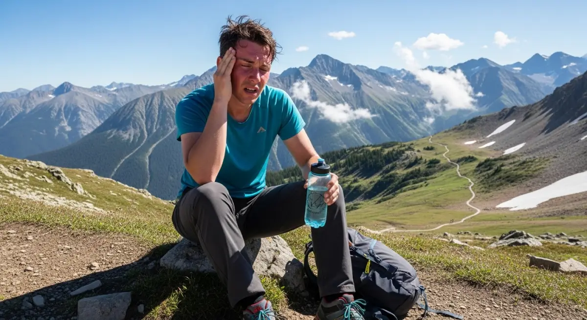
Symptoms That Ruin Adventures
Acute mountain sickness symptoms mirror a severe hangover, with headache serving as the cardinal symptom. Additional symptoms include:
Fatigue and weakness even when resting
Dizziness and lightheadedness
Nausea and vomiting
Loss of appetite
Difficulty sleeping despite exhaustion
Shortness of breath during minimal exertion
Symptoms typically develop within 2-12 hours of arrival at high elevation, often appearing during or after the first night—meaning tourists wake up feeling terrible on the day they'd planned their big adventure.
The symptoms typically last one to two days, with mean duration at 10,000 feet being approximately 15 hours. However, this assumes the person stops ascending and rests. Tourists who push through symptoms and climb higher risk progression to life-threatening conditions.
When Altitude Sickness Becomes Life-Threatening
High Altitude Cerebral Edema (HACE) represents brain swelling caused by altitude. It typically develops after a traveler has been at high elevation for at least three days without proper acclimatization, often after acute mountain sickness symptoms have already started. Symptoms progress from headache to confusion, difficulty walking, and coma. The mortality rate is extremely high unless patients can be rapidly evacuated to lower elevation.
High Altitude Pulmonary Edema (HAPE) causes fluid accumulation in the lungs through a different mechanism. The pulmonary artery constricts in response to lower oxygen, causing increased pressures that force fluid into the lungs. Symptoms include cough, difficulty breathing, and chest pain. The mortality rate reaches approximately 50% if a patient cannot be rapidly evacuated to lower elevation.
The treatment for both conditions is identical: descend immediately. The problem is that remote Colorado trails often require hours of technical driving to reach lower elevation. You can't simply "pull over and rest" when you're 20 miles from pavement on the Alpine Loop at 12,500 feet.
How Colorado Elevation Destroys Vehicle Performance
The same thin air that steals your oxygen steals your engine's power—a mechanical reality that transforms capable vehicles into struggling underperformers at elevation.
The 3% Rule That Rental Companies Never Mention
Naturally aspirated engines lose approximately 3% of their power for every 1,000 feet of elevation gain. This isn't opinion—it's atmospheric physics. Less air density means less oxygen entering the engine, which means less complete combustion, which means less power output.
The math is brutal for Colorado's high passes. At Denver (5,280 feet), a naturally aspirated engine loses approximately 15% of its sea-level power. At Silverton (9,318 feet), that loss reaches approximately 28%. At Engineer Pass (12,800 feet), power loss approaches 38%. That 300-horsepower SUV you rented at Denver International Airport produces roughly 255 horsepower by the time you reach Silverton, and only about 186 horsepower at Engineer Pass summit.
The steep grades and technical obstacles that vehicle handled confidently at lower elevation now challenge an engine producing barely 60% of its rated capability. Hills that barely required acceleration at sea level now demand full throttle while the vehicle crawls upward. Momentum you'd normally maintain disappears as the engine struggles to produce power your right foot demands but physics prevents.
Why Stock Rental SUVs Struggle at Elevation
Stock rental vehicles face compounding problems at Colorado elevation beyond raw power loss. Cooling systems designed for sea-level operation work harder when engines labor at altitude. Automatic transmissions generate excessive heat when crawling over obstacles with diminished power. Brake systems handling steep descents for extended periods overheat more quickly when thinner air reduces their cooling efficiency.
The fuel octane issue adds another complication. Gas stations at high altitude typically offer lower octane fuel—85, 87, and 89 rather than the 87, 89, and 91 available at sea level. This occurs because naturally aspirated engines at altitude don't require high octane since thinner air reduces knock tendency. However, if your rental vehicle requires 91 octane (as many modern turbocharged vehicles do), you may struggle to find appropriate fuel in mountain communities.
Modern fuel-injected vehicles automatically adjust fuel delivery and ignition timing to compensate for altitude, but this compensation can only partially offset the fundamental power loss from reduced air density. The vehicle operates safely, but it operates with significantly diminished capability.
Turbocharged Engines: The Elevation Advantage
Turbocharged engines perform dramatically better at altitude than naturally aspirated alternatives. Turbochargers compress incoming air before it enters the engine, essentially forcing more oxygen molecules into the combustion chambers despite the thinner ambient atmosphere.
Where naturally aspirated engines lose 3% power per 1,000 feet, turbocharged engines lose roughly 1% per 1,000 feet—and some high-performance turbo systems maintain nearly sea-level power up to significant altitudes before reaching their boost limits. At 10,000 feet, a 300-horsepower naturally aspirated engine produces approximately 210 horsepower, while a similarly-rated turbocharged engine might produce 270 horsepower or more.
This explains why properly equipped vehicles maintain confident performance on Colorado's highest passes while rental SUVs labor and struggle on the same terrain.
Trail-Specific Elevation Challenges
Colorado's famous 4x4 trails each present unique elevation challenges that compound with technical difficulty.
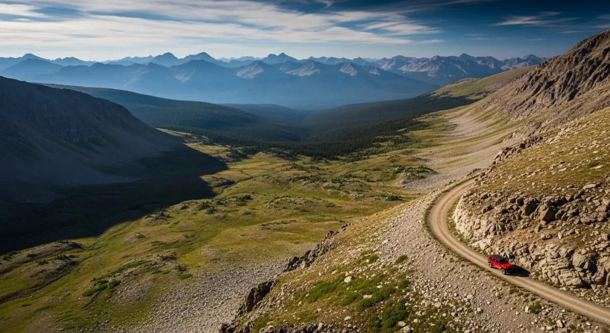
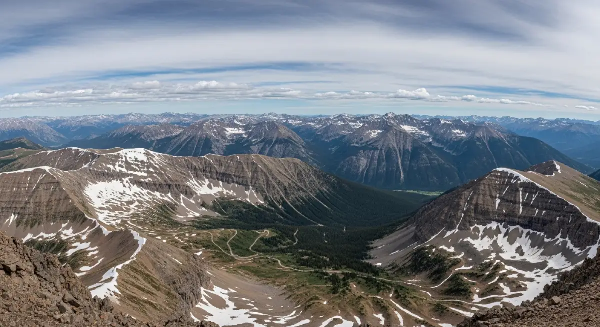
The Alpine Loop: 65 Miles Above Treeline
The Alpine Loop Backcountry Byway exemplifies Colorado elevation challenges, connecting Lake City, Ouray, and Silverton through 65 miles of high-altitude terrain that tourists consistently underestimate.
Starting from Lake City at 8,671 feet, the loop climbs through two major passes. Cinnamon Pass reaches 12,620 feet while crossing the Continental Divide, offering views of Handies, Sunshine, and Redcloud peaks—three of Colorado's famous fourteeners. Engineer Pass climbs even higher to 12,800 feet, providing vantage points over Uncompahgre and Wetterhorn peaks with views extending into Utah on clear days.
The trail passes through Animas Forks ghost town at 11,200 feet—where 25 feet of snow fell in 23 days during 1884, demonstrating the extreme weather these elevations produce. The route requires 7+ hours to complete, meaning visitors spend extended periods at elevations exceeding 12,000 feet where both human and mechanical performance degrade significantly.
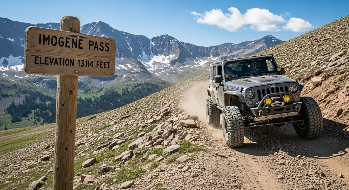
Imogene Pass: 13,114 Feet of Thin Air
Imogene Pass ranks among Colorado's highest drivable passes, connecting Telluride and Ouray through terrain that separates prepared adventurers from those who overestimated their capability.
The trail climbs from Telluride at 8,750 feet through the historic Tomboy Mine district, gaining over 4,300 vertical feet in roughly 19 miles. The ascent passes abandoned mining structures, waterfalls, and alpine wildflower meadows before reaching a summit that exceeds 13,000 feet—higher than most peaks in the continental United States outside Colorado.
Naturally aspirated vehicles that started the climb with reasonable power find themselves gasping at the summit, their engines producing barely 60% of sea-level capability while navigating rocky terrain that requires careful line selection and consistent momentum. Meanwhile, drivers experiencing altitude sickness symptoms must maintain focus despite headaches, dizziness, and impaired judgment affecting their decisions on single-lane shelf roads with significant exposure.
Black Bear Pass: Technical Difficulty Meets Thin Air
Black Bear Pass combines extreme technical difficulty with extreme elevation—a combination that separates prepared drivers from those who overestimated their capability.
The infamous descent features tight switchbacks on shelf road carved into near-vertical cliffs, with drops exceeding 1,000 feet. The "Waterfall" section requires precise vehicle control while engines produce 35%+ less power than rated and drivers potentially experience altitude sickness symptoms affecting judgment and coordination.
The pass operates one-way (descending from Telluride toward Ouray) specifically because the combination of steep grades and elevation-induced power loss makes uphill travel dangerous. Even descending, drivers must rely heavily on engine braking while managing brake temperatures on extended steep sections—all while their bodies struggle to process oxygen at altitudes where commercial aircraft maintain cabin pressure.
Planning for Colorado Elevation
Successful Colorado adventures require honest acknowledgment of elevation challenges and appropriate preparation—not optimistic assumptions that ignore atmospheric physics.
Acclimatization: The Only Reliable Prevention
The single most effective altitude sickness prevention is gradual acclimatization. Medical experts recommend spending 24-36 hours at intermediate elevation before ascending higher. For visitors flying into Denver from sea level, this means spending at least one day in Denver (5,280 feet) before traveling to mountain communities.
The general guidance suggests ascending no more than 1,500 feet per day when traveling above 8,000 feet. This means tourists flying into Denver on Monday shouldn't attempt 12,000+ foot passes until Wednesday at earliest—a timeline that conflicts with most vacation schedules but aligns with physiological reality.
Stay aggressively hydrated with 2-3 liters of water daily minimum. Avoid alcohol during the first few days at altitude—it worsens symptoms and accelerates dehydration. Limit caffeine, which also promotes dehydration. Eat lighter meals high in carbohydrates. Get plenty of rest. Recognize early symptoms and descend if they worsen rather than pushing through.
For those with previous altitude sickness history, prescription medications like acetazolamide (Diamox) can help speed acclimatization. Started 24-48 hours before ascent and continued for 48 hours after reaching maximum elevation, it can significantly reduce symptom severity. Consult a physician before travel if this applies to your situation.
Vehicle Preparation for High-Altitude Performance
For Colorado's highest passes, vehicle preparation must account for elevation-induced performance loss:
Full fuel tank before entering remote areas—no gas stations exist on the Alpine Loop between towns spanning 65+ miles of trail
Verified cooling system condition before extended high-altitude operation where engines work harder with less power
Confirmed low-range 4WD functionality—steep grades absolutely require low gearing when power is diminished
Recovery equipment including tow straps, shackles, and ideally a winch—getting stuck at elevation complicates everything when physical exertion exhausts oxygen-deprived rescuers
Extra water and emergency supplies—self-rescue may require extended physical effort at altitude where simple tasks become exhausting
Timing Considerations
Colorado's highest passes have extremely limited operating windows. The Alpine Loop typically opens June through September, with exact dates depending on snowpack. Early season (June) and late season (September-October) bring increased weather volatility and potential for snow even during "open" periods.
Start early in the day—before 8 AM if possible. Afternoon thunderstorms are common above treeline during summer months, developing rapidly and producing lightning, hail, and temperature drops of 30+ degrees within minutes. Getting caught at 12,800 feet during a lightning storm with suddenly icy roads transforms adventure into emergency.
Weather at elevation changes faster than weather radar predicts. Clear mornings become violent afternoon storms with regularity that locals understand but tourists consistently underestimate.
The Cliffhanger Advantage at Colorado Elevation
Cliffhanger Jeep Rentals operates locations specifically positioned for Colorado's high-elevation adventures—Silverton, Telluride, Durango, Moab, and Vernal—providing vehicles and local expertise designed for the unique challenges Colorado elevation creates.
Vehicles Built for Thin Air Performance
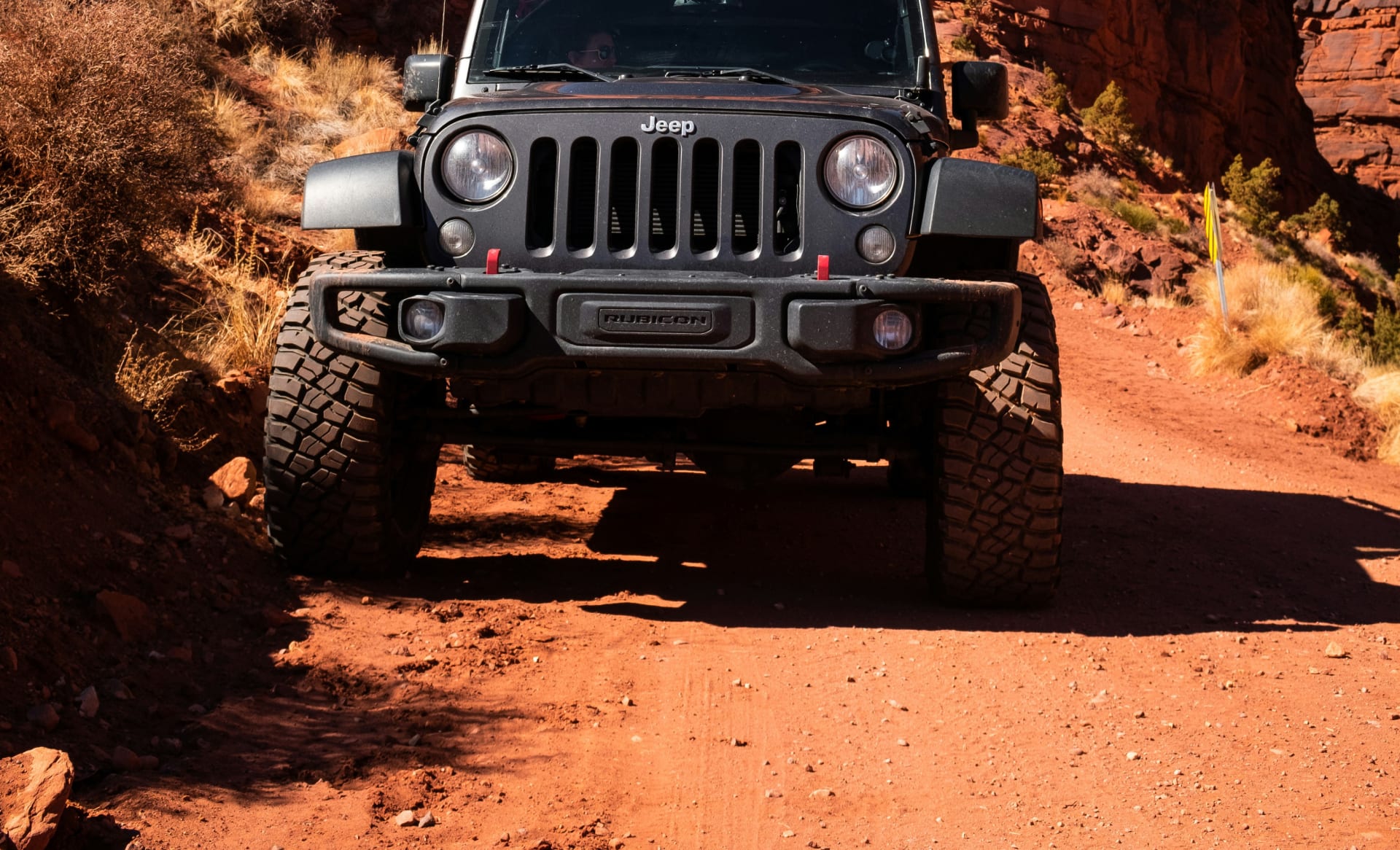
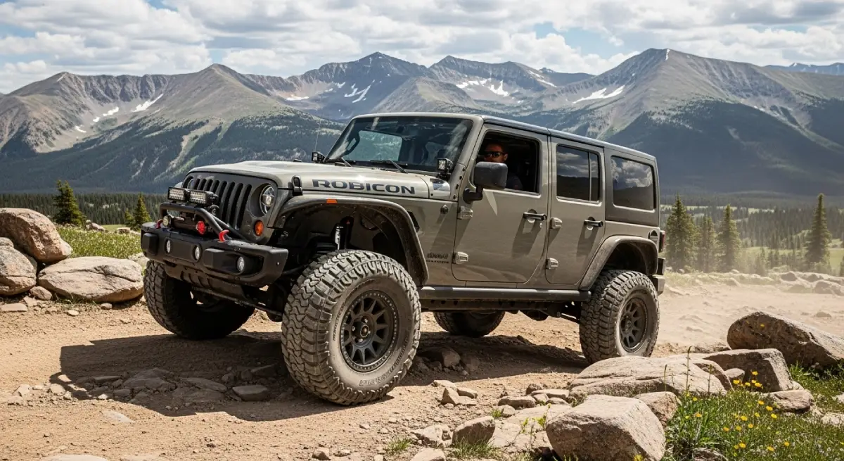
Our modified Rubicons maintain confident performance at elevation because they're designed and maintained for exactly these conditions. Where stock rental SUVs lose 30%+ of their power at Engineer Pass summit, our vehicles deliver the capability you actually need when you need it.
Our modifications address elevation challenges directly. Suspension lifts of 2.5-3.5 inches provide 11.5-13+ inches of ground clearance for obstacles that become more challenging when diminished power reduces your momentum margin. Aggressive 35-39 inch tires maintain traction on rocky terrain where power limitations mean you can't simply power through difficult sections. Complete skid plate protection prevents the undercarriage damage that becomes dramatically more consequential when you're 20 miles from help at 12,000 feet with no cell service.
Upgraded cooling systems handle the extended high-rpm operation that thin air demands from laboring engines. Steel bumpers with proper approach angles protect against the rock strikes that occur when technical obstacles meet reduced power margins. Recovery equipment comes standard because self-rescue capability matters when the nearest tow truck is hours away over trail terrain.
Local Expertise at Altitude
Our Silverton location sits at 9,318 feet—our staff lives and works at elevation daily. They understand which trails are appropriate for visitors still acclimatizing versus those who've spent several days adjusting. They know current conditions on passes that may look open on maps but feature lingering snow or recent storm damage.
This local knowledge prevents the mistakes that create emergencies. We don't send first-day visitors up 13,000-foot passes because we understand the compounding dangers that creates. We provide honest assessment of trail conditions and realistic difficulty ratings that account for elevation—not just technical obstacles.
When you ask about trail conditions, you're getting information from people who drove those trails yesterday, not from someone reading a website description written for sea-level tourists.
Positioned for Colorado's Best High-Elevation Trails
Our Colorado locations provide direct access to the state's most spectacular high-elevation trails. The Alpine Loop, Imogene Pass, Black Bear Pass, Ophir Pass, and dozens of other legendary routes sit within easy reach of our Silverton, Telluride, and Durango locations.
This geographic positioning means you're not adding hours of highway driving to reach trailheads—you're starting your adventures from appropriate staging points where you can spend your acclimatization time at elevation rather than at sea level, where our staff can provide current conditions, and where realistic expectations for what elevation will demand from both you and your vehicle come standard with every rental.
Experience Colorado Elevation Respectfully
Colorado elevation from Denver's mile-high airport to Engineer Pass's 12,800-foot summit represents the environmental reality that transforms accessible adventures into genuine challenges. The 25% altitude sickness rate, the 30%+ vehicle power loss, the rapidly changing weather above treeline—these aren't obstacles to overcome through determination. They're atmospheric physics that don't care about your vacation budget, fitness level, or how many off-road YouTube videos you watched before arriving.
But experiencing Colorado's high-elevation trails safely and successfully is absolutely achievable with honest capability assessment and appropriate preparation. The gap between what sea-level tourists expect versus what atmospheric physics actually delivers creates those consistent search-and-rescue statistics and abandoned adventure plans. Closing that gap requires vehicles that perform at elevation, expertise from people who live at altitude, and realistic timelines that allow acclimatization.
Cliffhanger Jeep Rentals eliminates the capability gap. Our modified vehicles maintain performance at elevation that stock rentals can't match. Our Colorado locations provide local expertise from staff who understand altitude challenges from daily experience. Our honest assessment of conditions prevents the mistakes that transform adventures into emergencies.
Ready to experience Colorado's legendary high-elevation trails—from the Alpine Loop's 12,800-foot passes to Imogene's 13,114-foot summit to the technical challenges that define the San Juan Mountains—with proper equipment and the confidence that comes from vehicles and expertise actually built for thin air? Contact Cliffhanger Jeep Rentals in Silverton, Telluride, Durango, Moab, or Vernal and discover why thousands of adventurers trust us for terrain where elevation separates prepared exploration from expensive mistakes.
The ghost towns, the alpine tundra, the passes above treeline, the views extending into neighboring states—Colorado elevation reveals its complete character only to those who approach with honest respect for atmospheric physics rather than optimistic assumptions. The trails are waiting. The question is whether you're genuinely prepared for what they demand.