What Nobody Tells You Before You Drive the Alpine Loop Colorado
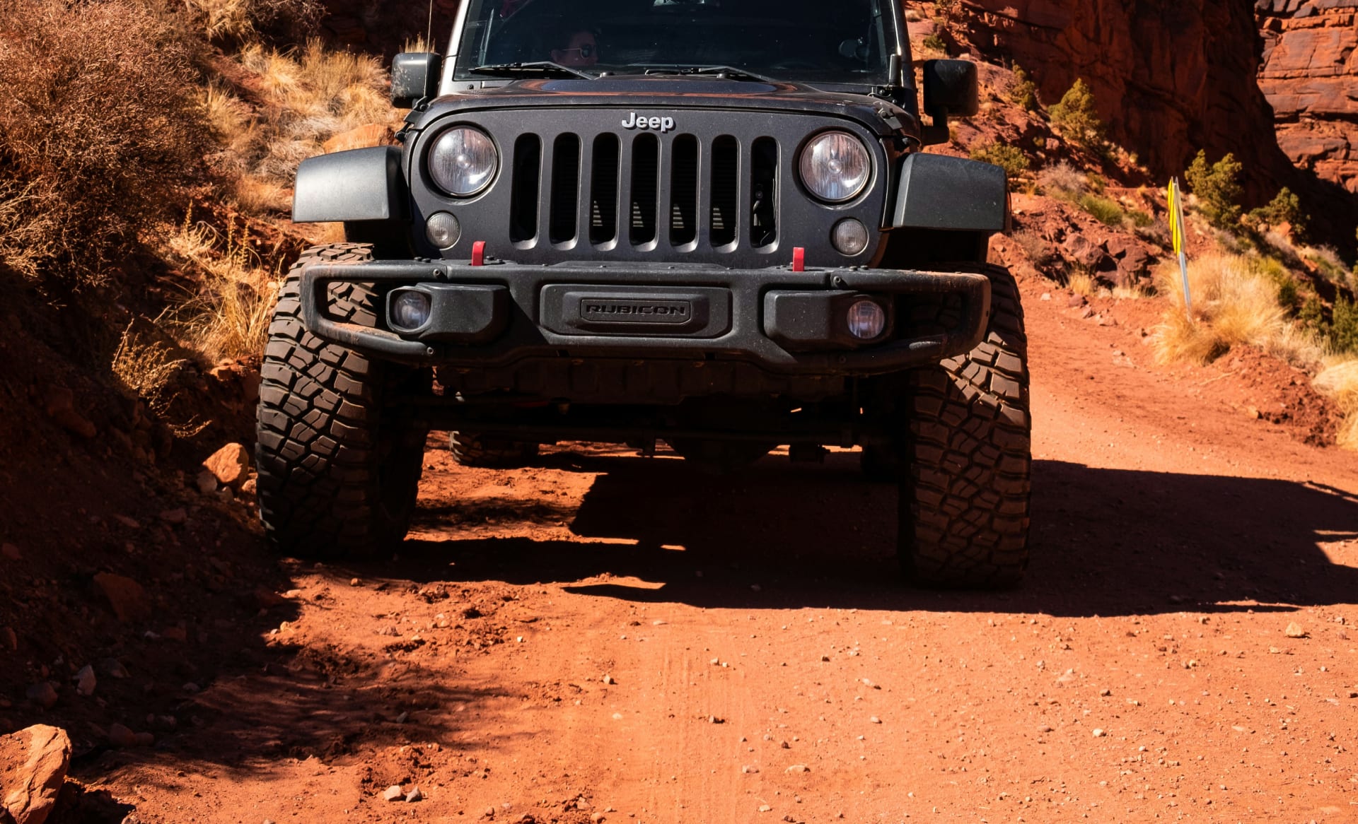
Here's what the scenic byway pamphlets conveniently omit about the Alpine Loop Colorado: only four miles of the entire 63-mile route are paved, the two high passes topping 12,600 feet require genuine 4WD low-range capability to navigate safely, and the shelf roads carved into near-vertical San Juan Mountain cliff faces feature single-lane exposure that makes underpowered and under-cleared vehicles a liability to themselves and everyone else on the trail.
The Alpine Loop Colorado isn't a scenic drive with a couple of rough patches. It's one of the most famous 4x4 backcountry byways in the American West—a former mining corridor connecting Lake City, Silverton, and Ouray through terrain that stopped stagecoaches, buried towns under avalanches, and produced fortunes in silver and gold before being largely abandoned when the ore ran out in the 1890s. The roads that remain are the original routes, maintained but fundamentally unchanged from when mule-drawn ore wagons hauled freight across passes that top 12,800 feet.
Over 100,000 people attempt the Alpine Loop each summer. The ones who get the most out of it—and avoid the recoveries that make search-and-rescue logs colorful reading—are the ones who arrive with the right vehicle, the right information, and an honest understanding of what the terrain actually demands.
The Alpine Loop Colorado at a Glance
The basics:
Total distance:
63 miles of connected 4x4 roads
Paved miles:
4 (in Lake City only)
High points:
Engineer Pass at 12,800 feet, Cinnamon Pass at 12,640 feet
Towns connected:
Lake City, Silverton, Ouray
Typical season:
Late May through September, weather dependent
Drive time:
6–8 hours for the full loop with stops, longer with optional side routes
Vehicle requirement:
High-clearance 4WD with low-range gearing (4LO)
What it covers:
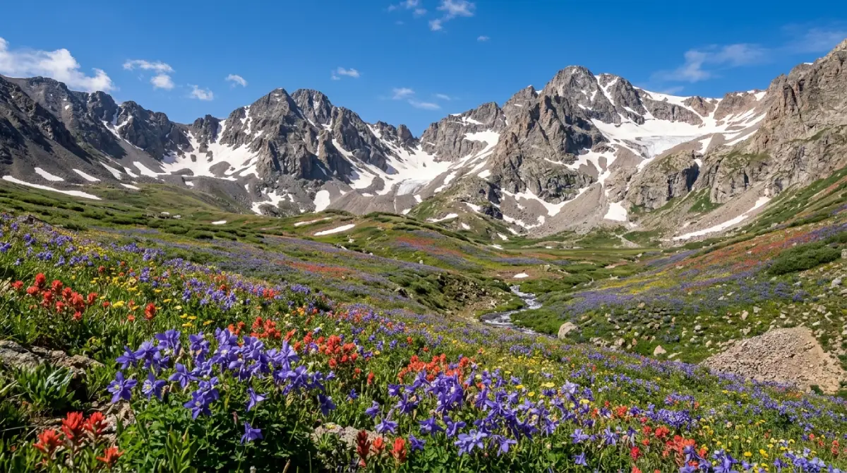
The loop follows former toll roads and ore wagon routes built in the late 1870s by Otto Mears—a Russian immigrant engineer who constructed most of Colorado's early mountain road network. The route passes through multiple preserved and partially intact ghost towns, a half dozen historically significant mine sites, alpine tundra above treeline, wildflower basins that rival anything in the Rocky Mountains, and two passes that place drivers in the exposed San Juan high country with panoramic views that extend to Utah on clear days.
Designated status:
The Alpine Loop holds both Colorado Scenic and Historic Byway designation and Bureau of Land Management Backcountry Byway designation—a formal acknowledgment that the route's historical and scenic significance warrants protection and stewardship. Engineer Pass is also a Jeep Badge of Honor trail, part of the official recognition program for completing Colorado's most significant 4x4 routes.
Engineer Pass: The Loop's Most Technical Segment
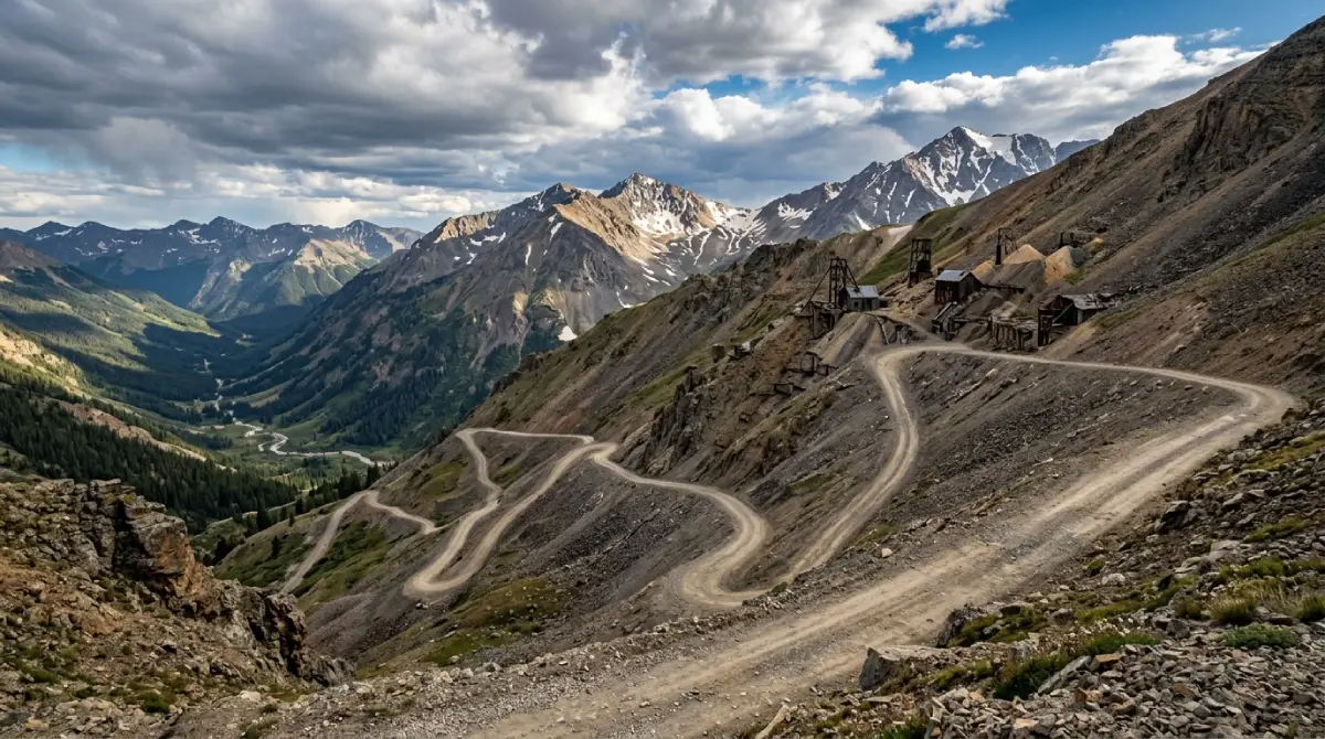
Engineer Pass at 12,800 feet is the Alpine Loop's highest point and its most demanding section. Built in 1877 as a toll road and stagecoach route between Ouray, Animas Forks, and Lake City, the west side descent from the summit into the Mineral Creek drainage is where the loop earns its reputation.
What the ascent delivers:
From the Ouray approach via Mineral Creek (County Road 18), the road climbs steadily through the canyon before reaching the junction with the Alpine Loop proper at Animas Forks. The section from Animas Forks to the Engineer Pass summit transitions from manageable backcountry road to legitimately technical terrain—steep rocky switchbacks, loose surface in sections, and tight single-lane shelf road on the exposed upper mountain face.
The summit experience:
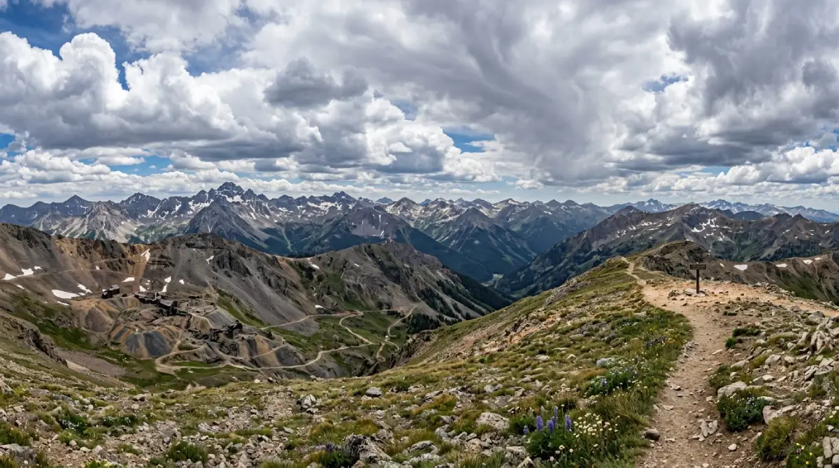
At the top of Engineer Pass, the views extend across the full San Juan Mountain range in every direction. Uncompahgre Peak (14,309 feet) and Wetterhorn Peak (14,015 feet) dominate the eastern skyline. To the west on a clear day, the terrain flattens toward the Uncompahgre Plateau and beyond. The road crosses American Flats—a broad stretch of alpine tundra above treeline—where the scale of the high country becomes fully apparent. Oh Point and Odom Point overlooks just below the true summit are the most photographed spots on the entire loop.
Technical specifics:
The west side descent from the summit into Mineral Creek is rated moderate to difficult. Narrow shelf road, steep drop-offs, and loose rocky surface in sections.
4LO engagement strongly recommended on the descent. Engine braking on steep grades with a properly geared low range provides control that service braking alone doesn't match.
Single-lane sections require backing to the nearest wide spot when meeting opposing traffic. Anticipate this and drive accordingly—aggressive approaches to blind corners create the problems that make recovery calls necessary.
Cell service is nonexistent throughout. Download offline maps, communicate the planned route before departure, and carry a first aid kit and basic recovery gear.
Historical sites along the route:
Capitol City ghost town
— Founded in 1877 by George Lee, who genuinely believed it would become Colorado's state capital. Today, a few crumbling stone foundations remain of his ambitious plan, accessible via a short side trip from the Henson Creek road.
Rose's Cabin
— A preserved stage stop from 1874, built by Corydon Rose as a rest point for travelers crossing between Ouray and Lake City. One of the best-preserved examples of the Alpine Loop's staging infrastructure.
Empire Chief Mine
— Visible from the road below Engineer Pass. Destroyed by an avalanche in 2008, the ruins provide context for how aggressively avalanche terrain shaped and ultimately ended mining activity throughout the San Juans.
Whitmore Falls
— A short walk from the road on the Lake City side of Engineer Pass. The overlook provides views of the falls without the descent; a steep 0.1-mile trail reaches the base for a more complete view and, in appropriate conditions, a cold swim.
Cinnamon Pass: The Loop's Scenic Anchor
Cinnamon Pass at 12,640 feet is generally considered the more approachable of the two Alpine Loop passes—the ascent from Animas Forks is less technically demanding than Engineer's west face, though the summit terrain above treeline requires the same 4WD commitment. What Cinnamon delivers in trade for slightly reduced technicality is consistently superior wildflower scenery from late June through early August.
The route from Animas Forks:
Leaving the Animas Forks ghost town heading east, the road climbs steadily through the California Gulch drainage before breaking above treeline onto the open alpine slopes below the pass. The Tobasco Mine ruins appear mid-climb—the old tramway posts that carried ore down from the mine to the valley mill are visible against the hillside, providing one of the loop's clearest illustrations of the industrial scale that once operated in this remote terrain.
The summit:
At 12,640 feet, Cinnamon Pass delivers unobstructed 360-degree views across the San Juan backcountry. The descent toward Lake City drops into the Lake Fork of the Gunnison River drainage, transitioning from exposed alpine terrain into a dramatic mountain valley with the road following the river downstream.
American Basin:
One of the most celebrated wildflower destinations in Colorado sits just off the Cinnamon Pass route in a side drainage accessible by high-clearance 4WD. American Basin's mid-July transformation—columbine, Indian paintbrush, lupine, and blue flax covering every slope visible from the basin floor—draws photographers from across the country during peak bloom. The trailhead for Handies Peak (14,048 feet), rated as one of Colorado's easiest 14er summits, begins at the basin. Crystal-blue Sloan Lake, 2 miles up the Handies trail, is a worthwhile destination even for non-summit attempts.
Technical specifics:
Cinnamon Pass from the Animas Forks side: moderate difficulty. High-clearance 4WD required but less sustained technical engagement than Engineer's west face.
The Lake City descent on the east side is generally easier than Engineer's descent—the road is wider in sections and the grade is less sustained.
Weather changes fast above treeline on both passes. Afternoon thunderstorms develop by 2 PM most summer days. Plan to be off exposed sections before noon. Snow is possible on both pass summits even in July.
Animas Forks: The Loop's Historical Heart
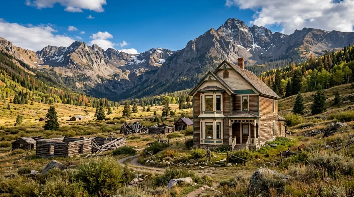
At the junction of the Engineer Pass and Cinnamon Pass routes sits Animas Forks—one of Colorado's most intact and most accessible ghost towns. Located at 11,200 feet at the confluence of three drainages in the upper Animas River watershed, Animas Forks operated as a supply hub serving the surrounding mine network from 1873 through the silver crash of 1893.
What survives:
Multiple original structures remain standing at Animas Forks, including the Duncan House (a two-story Victorian with bay windows at nearly 12,000 feet elevation—one of the most photographed buildings in Colorado's ghost town catalog), mine manager residences, and numerous collapsed cabin sites spread across the valley floor. The BLM maintains the site and has installed interpretive signs throughout.
Context:
At its peak, Animas Forks supported a population of approximately 450 people, a 30-room hotel, a newspaper, a post office, and a town hall. Avalanches regularly buried portions of the town during winter—residents designed some structures with angled rooflines specifically to deflect snow loads. The entire town was abandoned by 1920 after the final mines played out. The isolation that made it historically inaccessible for decades is exactly what preserved so much of its structure.
Logistics:
Animas Forks is the natural stopping point between Engineer and Cinnamon passes—budget 45–60 minutes for a proper exploration of the site. Interpretive signs explain each structure's history. No facilities, no services. Pack out all waste.
Poughkeepsie Gulch: The Optional Expert-Level Addition
For drivers who complete the main Alpine Loop and want more, Poughkeepsie Gulch connects the loop to Ouray via a route that significantly raises the technical demand.
What it involves:
Poughkeepsie Gulch descends from the Engineer Pass area toward Ouray through narrow canyon terrain with obstacles that require lockers, significant articulation, and experienced driving. The route is widely considered one of the most technically demanding standard 4x4 trails in the San Juans—not the extreme rock crawling of Ouray's dedicated obstacles, but sustained technical terrain that eliminates stock and minimally modified vehicles quickly.
Vehicle requirement:
Lockers front and rear are the practical requirement for Poughkeepsie Gulch's most demanding sections. High-clearance, aggressive tires, and 4LO are baseline. This is not an appropriate addition to the loop for first-time backcountry drivers or stock vehicles regardless of 4WD designation.
The payoff:
The descent into Ouray from the Poughkeepsie side provides one of the most dramatic approaches to any Colorado mountain town—the valley opening up below as the road descends the canyon walls delivers a visual reward that the standard Ouray approach from US-550 can't match.
The Three Gateway Towns: What Each One Delivers
Lake City
The Alpine Loop's traditional starting point sits in the Hinsdale County seat at 8,671 feet on the Lake Fork of the Gunnison River. Lake City is a genuinely preserved 19th-century mountain town—the Victorian commercial architecture on Silver Street is intact in a way that most Colorado mining towns aren't—with a population of roughly 400 that triples in summer as the Alpine Loop visitor season opens.
Lake San Cristobal
— Colorado's second-largest natural lake (formed by the Slumgullion Earthflow, a massive landslide that dammed the river around 700 years ago) sits just south of town. Fishing, kayaking, and paddleboarding are popular warm-up activities before or after a loop day.
Services:
Gas, restaurants, basic groceries, and lodging. The last reliable fuel before the full loop from the Lake City side. Fill up here.
Vibe:
Quiet, historic, genuinely local. Less tourist infrastructure than Silverton or Ouray, which is either a limitation or an appeal depending on preference.
Silverton
Silverton anchors the Alpine Loop's southern access and provides the most direct approach to Animas Forks from the loop's technical heart. Sitting at 9,318 feet in a high valley ringed by 13,000-foot peaks, Silverton's entire economy has operated around mining, railroad, and now 4x4 tourism for 150 continuous years.
Blair Street and the National Historic Landmark District
— The commercial and residential grid Silverton established in 1874 is largely intact, including the Victorian storefronts and saloon row that served the mining boom.
Durango & Silverton Narrow Gauge Railroad
— The historic steam-powered railroad that ran ore from Silverton to Durango still operates as a tourist railroad. Arriving in Silverton by train and departing by Jeep (or vice versa) is a legitimate and memorable combination.
Cliffhanger's Silverton location
— The most strategically positioned base for the Alpine Loop. Silverton puts you within 14 miles of Animas Forks on County Road 2—close enough that both Engineer and Cinnamon passes are achievable in a single day without the logistical overhead of driving from Ouray or Lake City.
Ouray
The "Switzerland of America" sits at 7,792 feet at the bottom of a box canyon with peaks rising 8,000 feet above the valley floor in every direction. Ouray is the most developed of the three Alpine Loop towns—established tourist infrastructure, a thriving restaurant scene, and natural hot springs pools that make post-loop recovery genuinely appealing.
Ouray Hot Springs
— The municipal hot springs pool and several private hot springs spas operating in town provide a post-loop soak that earns its place in the itinerary on physical merit. After a full day on rocky high-pass terrain, heated mineral water is not an optional indulgence.
Box Canyon Falls
— A short hike from downtown drops into a narrow canyon where Box Canyon Creek drops 285 feet through a crack in the rock barely 20 feet wide. Worth the 30 minutes.
Cliffhanger's Ouray adjacent access
— The Mineral Creek road from Ouray provides the western approach to Engineer Pass. Ouray-based drivers typically tackle the loop via the more demanding Mineral Creek approach before connecting to the full loop circuit at Animas Forks.
Driving the Alpine Loop: Direction, Timing, and Honest Preparation
Direction decision:
The clockwise direction from Lake City (Cinnamon Pass first, Engineer Pass second) is generally recommended for first-time loop drivers. This approach places the vehicle on the inside lane of mountainous shelf road sections with the driver positioned toward the cliff rather than the drop-off—a psychological and safety advantage on first exposure. The counter-clockwise direction (Engineer first) is preferred for less powerful 4WD vehicles that may struggle with Engineer's steep west-face ascent—tackling it fresh from the Lake City side with more power reserve is the practical argument.
Timing:
Start by 7–8 AM to clear both passes before afternoon thunderstorm development. The standard Moab-style advice applies here: be off exposed ridgelines and summits by noon.
Budget 6–8 hours for the full loop with stops at Animas Forks, American Basin overlook, and the major pass summits. Adding Poughkeepsie Gulch or the Handies Peak approach extends the day significantly.
The loop is typically open late May through September. Snowpack varies year to year—confirm current conditions with BLM Gunnison before departure. Both passes can have snowpack well into June following heavy winter years.
What to bring:
Minimum 2 liters of water per person—altitude increases dehydration rate significantly
Warm layers regardless of Silverton or Ouray weather at departure. Summit temperatures can be 30°F cooler than valley conditions with wind chill additional factor
Recovery straps and a basic toolkit. The loop sees enough traffic that help arrives eventually if needed, but self-sufficiency is always the better plan
Offline maps downloaded before departure. Cell service is nonexistent throughout most of the loop
Why Cliffhanger for the Alpine Loop Colorado
The Alpine Loop's technical demands separate it from casual mountain driving clearly and early. The Mineral Creek approach to Engineer Pass from Ouray is rated a strong 2.5 difficulty—not suitable for stock or minimally cleared vehicles. Both passes require 4LO capability on the descent. The shelf roads require sufficient clearance and suspension articulation that stock crossovers and highway-tire SUVs consistently fail to provide confidently.
Cliffhanger's Silverton location is the natural starting point for the Alpine Loop done right.
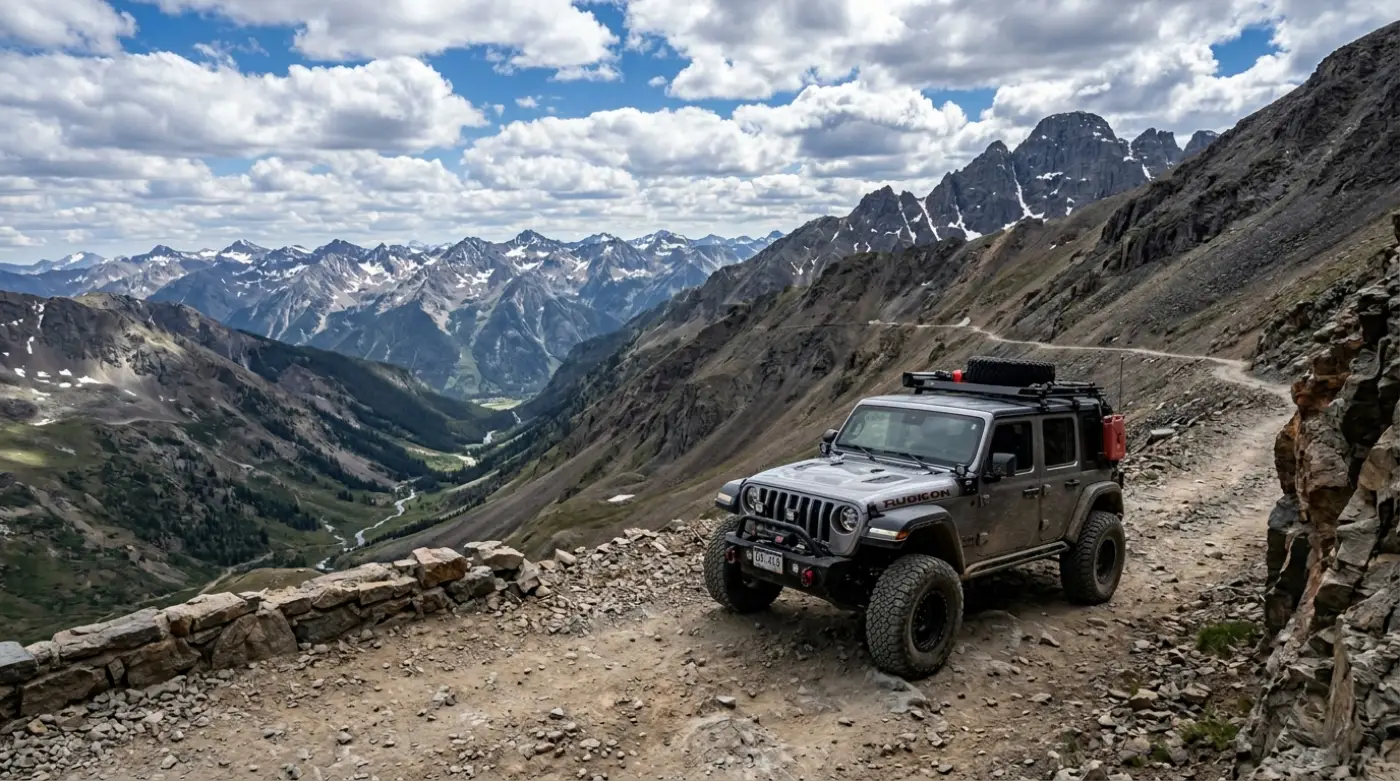
What Cliffhanger's Silverton Rubicons provide:
2.5-inch lift with 35-inch aggressive tires: clearance and tire grip for the rocky high-pass sections that challenge stock vehicles at every obstacle
Extreme Rubicons with 3.5-inch lift and 39-inch tires: the configuration for Poughkeepsie Gulch and the loop's most technical optional additions
Full skid plate protection: oil pan, transmission, and transfer case coverage that turns rock contact into a non-event rather than a trip-ending damage moment
4LO capability: the actual low-range gearing that pass descents and technical ascents require—not the AWD AUTO modes that provide neither the control nor the engine braking that matters
Local staff with current conditions: trail status changes with weather and season; Silverton-based staff know the loop's current state before you head out
The Alpine Loop Colorado is one of the defining 4x4 routes in the American West. It rewards proper preparation with ghost town history, wildflower basins, 12,800-foot summit views, and the San Juan Mountain scenery that puts this corner of Colorado in the same conversation as anywhere on the continent. It also creates consistent search-and-rescue calls from vehicles and drivers that arrived unprepared.
Cliffhanger exists to make sure your loop falls in the first category.
Ready to drive the Alpine Loop Colorado in a vehicle built for every mile of it? Contact Cliffhanger Jeep Rentals in Silverton and let's put together the configuration that makes the loop what it's supposed to be.